Description:
205 x 137 cm. extra ordinary Ottoman wall map of the Ottoman Europe prınted ın colors, folding paper on cloth. Signatures by the first lieutenant M. İhsan.
Search Results: MAPS from Archive
You searched for:
- Subject: MAPS from Archive
Results 1 - 14 of 14

More Photos
Avrupa-i Osmani Haritasi (Wall map of the Ottoman Europe), extra ordinary copy of an Ottoman lieutenant
- Used
- very good
- Condition
- Used - Very Good
- Quantity Available
- 1
- Seller
-
Riyadh, Saudi Arabia
- Item Price
-
SGD 9,658.60SGD 21.39 shipping to USA
Show Details
Item Price
SGD 9,658.60
SGD 21.39
shipping to USA

BAGDAD WILAYETI HARITASI (MAP OF BAGDAD PROVINCE)
- Used
- very good
- Signed
- Condition
- Used - Very Good
- Quantity Available
- 1
- Seller
-
Riyadh, Saudi Arabia
- Item Price
-
SGD 4,139.40SGD 21.39 shipping to USA
Show Details
Description:
Istanbul: MuhendisHane-i Berr-i Humatun (The Royal school of military engneering) Map. Very Good. No Binding. Signed by Illustrator(s). Folio - over 12" - 15" tall. LITHIOGRAPHY, 1860's AFTER THE TELEGRAF LINES HAS BEEN ESTABLISHED IN THE OTTOMAN STATES. PRINTED AND ORIGINALLY HAND COLORED IN THE MUHENDISHANE I BERRI HUMAYUN, USKUDAR, THE GROUND FORCES GEOMETRY SCHOOL (or better known: The Royal School of Military Engneering) ESTABLISHED DURING SULTAN SELIM III TIME LATE 18'th C. 39,5 X 39,5 CM. FIVE LINES OF DETAILS IN OTTOMAN. SIGNED: YUMNI. SCARCE. 0.
Item Price
SGD 4,139.40
SGD 21.39
shipping to USA
Map of Eyalet ic il ve Karaman ve Anadolu (Anatolia) ve Sivas. From Kitab-i Cihannuma
by Katip Celebi, Mustafa bin Abdullah (1609–1657), known as Haji Khalifa (Turkish: Hacı Halife)
- Used
- very good
- first
- Condition
- Used - Very Good
- Edition
- 1st Edition
- Quantity Available
- 1
- Seller
-
Riyadh, Saudi Arabia
- Item Price
-
SGD 4,829.30SGD 21.39 shipping to USA
Show Details
Description:
Sketched by İbrahim Tophanevi (attributed to Tophane) and made by Magradj (?) the Galataian (attributed to Galata in İstnabul). Conteporarily hand colored and hightend in gold, 36.5 x 30.5 cm.
Item Price
SGD 4,829.30
SGD 21.39
shipping to USA

More Photos
Map of Mavera nehr ve tevabii (countries of Beyond the river and environs) from Kitab-i Cihannuma
by Katip Celebi, Mustafa bin Abdullah (1609–1657), known as Haji Khalifa (Turkish: Hacı Halife)
- Used
- very good
- first
- Condition
- Used - Very Good
- Edition
- 1st Edition
- Quantity Available
- 1
- Seller
-
Riyadh, Saudi Arabia
- Item Price
-
SGD 4,829.30SGD 21.39 shipping to USA
Show Details
Description:
Made by Magradj (?) the Galataian (attributed to Galata in İstnabul). Conteporarily hand colored and hightend in gold. 37 x 30.5 cm.
Item Price
SGD 4,829.30
SGD 21.39
shipping to USA
Map of Ulu Tughay, Ciracassians and Abaza ethnic groups in Daghistan, Georgia, Van, Kars, Trabzon and Erzrum. From Kitab-ı Cihannuma
by Katip Celebi, Mustafa bin Abdullah (1609–1657), known as Haji Khalifa (Turkish: Hacı Halife)
- Used
- as new
- first
- Condition
- As New
- Edition
- 1st Edition
- Quantity Available
- 1
- Seller
-
Riyadh, Saudi Arabia
- Item Price
-
SGD 4,139.40SGD 21.39 shipping to USA
Show Details
Description:
Conteporarily hand colored and hightend in gold, 37 x 30.5 cm. Made by Ahmad the Crimean (signed).
Item Price
SGD 4,139.40
SGD 21.39
shipping to USA
Map of the Arabian peninsula including a particular small key map of al Der'iyyah خريطة الجزيرة العربية مع مفتاح خاص صغير لبلدة الدرعية في نجد: Der'iyya City بلدة الدرعية
by The Ottoman military geography school
- Used
- Condition
- Used
- Quantity Available
- 1
- Seller
-
Riyadh, Saudi Arabia
- Item Price
-
SGD 27,596.00SGD 21.39 shipping to USA
Show Details
Description:
80 x 75 cm. Made by the (kol agasi) Osman Nuri , the secretary of the geographical military school in 1323 Ah. 1907 Ad. Rarely contains a small key map of the city of Der'iyyah in Nejd territory , together with other keys of Medina , Taif , Mecca and Jeddah harbor.
Item Price
SGD 27,596.00
SGD 21.39
shipping to USA

More Photos
Map of the Safavids country (Map of İran) from Kitab-i Cihannuma
by Katip Celebi, Mustafa bin Abdullah (1609–1657), known as Haji Khalifa (Turkish: Hacı Halife)
- Used
- as new
- first
- Condition
- As New
- Edition
- 1st Edition
- Quantity Available
- 1
- Seller
-
Riyadh, Saudi Arabia
- Item Price
-
SGD 6,899.00SGD 21.39 shipping to USA
Show Details
Description:
Contemporarily hand colored and hightend ın gold, 37 x 30.5 cm. The map includes the coastal places of eastern Nejd on the Persian Gulf, as Bahrein and Oman.
Item Price
SGD 6,899.00
SGD 21.39
shipping to USA

More Photos
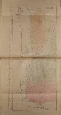
Military map of Vilayet Yemen
by General staff of the Ottoman authority
- Used
- Condition
- Used
- Quantity Available
- 1
- Seller
-
Riyadh, Saudi Arabia
- Item Price
-
SGD 13,798.00SGD 21.39 shipping to USA
Show Details
Description:
93 x 64 cm. Colored military map described in Ottoman Turkish. Province of Hejaz, Asir and Yemen by the fifth section in the general staff 1323 H., 1907 AD. Paper on cloth folded to 16 parts.
Item Price
SGD 13,798.00
SGD 21.39
shipping to USA
More Photos
OTTOMAN ATLAS CONTAINS THIRTY NINE HAND COLORED MAPS PREPARED AND PRINTED IN THE MUHENDISHANE I BERRI HUMAYUN (THE ROYAL SCHOOL OF MILITARY ENGNEERING) IN ISTANBUL. POSSIBLY THE FIRST ADMINISTRATIVE ATLAS TO BE PRINTED IN USKUDAR AFTER THE ESTABLISHMENT OF THE TELEGRAPH LINES IN THE OTTOMAN WILAYAS (STATES)
by THE OTTOMAN AUTHORITY
- Used
- very good
- Hardcover
- Signed
- Condition
- Used - Very Good
- Binding
- Hardcover
- Quantity Available
- 1
- Seller
-
Riyadh, Saudi Arabia
- Item Price
-
SGD 68,990.00SGD 21.39 shipping to USA
Show Details
Description:
Uskudar: MuhendisHane-i Berr-i Humatun (The Royal school of military engneering) Atlas. Illus. by YUMNI. Very Good. Hardcover. Folio - over 12" - 15" tall. 1860's THIRTY NINE HAND COLORED MAPS MOSTLY SIGNED BY (YUMNI). MOST OF THEM ARE DESCRIBED IN THE OTTOMAN TURKISH. ALL MAPS ON DOUBLE PAGES, TITLED AND WITH PRINTING DETAILS. LATER HARD COVER. FOLIO 40 X 28 CM. SCARCE. the maps are the followings: (1)Arabistan (Arabian peninsula) 56 x 47 cm. (2)Tarablus Gharb wa tunus (Libya and Tunisia) 56 x 39 cm. (3)Tarablus Gharb (Libya) 56 x 40 cm. (4)Misir ayalet I mumtaza si (territory of Egypt) 56 x 46 cm. (5)Yemen 69 x 33 cm. (6)Hejaz, 56 x 39 cm. (7)Ankara . (8)Sivas . (9)Ma'muat ul Aziz. (10)Diyar Bekir. (11)Bitlis. (12)Erzurum . (13)Van. (14)Mosul 56 x 39 cm. (15)Bagdad 56 x 39 cm. (16)Basra 55 x 39 cm. (17)Zor mutasarrifligi (Part of Mesopotamia. (18)Halep (Aleppo). (19)Adana. (20)Konya. (21)Kibris (Cyprus). (22)Caza'ir I Bahr I Sefid (the Wilaya of the Mediterranean sea islands). (23)Aydin. (24)Pega…
Read More Item Price
SGD 68,990.00
SGD 21.39
shipping to USA

More Photos
Official military Ottoman Atlas contains 44 colored maps
by General Ali Seref Pasha and others
- Used
- Hardcover
- first
- Condition
- Used
- Edition
- First and only
- Binding
- Hardcover
- Quantity Available
- 1
- Seller
-
Riyadh, Saudi Arabia
- Item Price
-
SGD 34,495.00SGD 21.39 shipping to USA
Show Details
Description:
38x28 cm. Open maps measures 38x52 cm. Some are handly colored. One index written in Ottoman Turkish. Printed in different printing houses by Ali Sharaf Pasha and others between 1892 and 1897 for the official military use. In contemporary binding. Rare Ottoman Atlas.
Item Price
SGD 34,495.00
SGD 21.39
shipping to USA
More Photos
RARE OTTOMAN MILITARY MAP OF KARA DAG (MONT NEGRO)
by Ottoman General Staff Section
- Used
- very good
- Condition
- Used - Very Good
- Quantity Available
- 1
- Seller
-
Riyadh, Saudi Arabia
- Item Price
-
SGD 6,899.00SGD 21.39 shipping to USA
Show Details
Description:
Istanbul: The general staff section, 1875 Map. Very Good. No Binding. Military map of Kara Dag (Mont Negro), Ottoman General staff section in 1291 (1875) after the map which made by the Austrian military geographical section in 1869 about Kara Dag and environs after the war and military movements of 1861-1862. Officially linen in colors by contemporary hands, 105 x 105 cm. Very rare..
Item Price
SGD 6,899.00
SGD 21.39
shipping to USA
al Tarikh al Harbi li 'asr Muhammad ali al Kabir (the militar history of the period of Mehmed ali the great, plans of some of the battles: Hims, Pilan, and Konya)
by Prince Omar Tosun (Omer Toussoun)
- Used
- very good
- Hardcover
- first
- Condition
- Used - Very Good
- Edition
- 1st Edition
- Binding
- Hardcover
- Quantity Available
- 1
- Seller
-
Riyadh, Saudi Arabia
- Item Price
-
SGD 3,242.53SGD 21.39 shipping to USA
Show Details
Description:
Cairo: The general staff, Intelligence Office, 1951 Book. Very Good. Hardcover. 1st Edition. Folio - over 12 - 15" tall. oblong folio, 42x28 cm. The royal assembly for the historical studies publication, the military movements plans of Ibrahim Pasha son of Mehmed Ali against the Ottoman authority in Syria and Anatolia, collected and edited by the prince Omar Tosun. 4 plans of the battle of Hims 9 July 1832, 4 plans of the battle of Bilan 30 July 1832, 6 plans of the battle of Konya 21 December 1832. Each plan is explained on the opposite in Arabic. Original printer wraps, spotted and partly repaired. Modersn fine hard covers binding..
Item Price
SGD 3,242.53
SGD 21.39
shipping to USA
More Photos
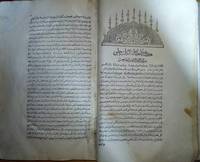
cihannuma or Jihannuma (Mirror of the world)
by KATIB CELEBI (Mustafa ibn Abd Allah, aka Haci Halife, 1609-1657)
- Used
- Fine
- Hardcover
- Condition
- Used - Fine
- Edition
- 1st Edition
- Binding
- Hardcover
- Quantity Available
- 1
- Seller
-
Riyadh, Saudi Arabia
- Item Price
-
SGD 117,283.00SGD 21.39 shipping to USA
Show Details
Description:
FIrst page of the preface and last page of the index are facsimiles, else; complete with 39 original maps and shapes, mint condition and wide complete margins. 698pp of Ottoman Turkish text, printed by Ibrahim Muteferrika in 1145 AH. - 1732 AD. In contemporary hard covers binding. FIRST AND ONLY EDITION OF THE JIHANNUMA. Planned as a great cosmosgraphy, the work was never completed, although Katib Celebi wrote two versions. The text contained here is the second version, rewritten after the author had acquired a Mercator-Hondius Atlas minor (Koemans mistakenly considered the Jihannuma a translation into Turkish of that Atlas). It covers the world from Japan to the Ottoman borders and is well-illustrated with engraved maps, including: the World in twin hemispheres, the World in oval projection, Europe, Africa, Asia, America, the North and South Poles, Arabia, Japan and various other parts of Asia and Asia Minor. Several of the maps and diagrams had appeared in earlier books printed by Mteferrika.The…
Read More Item Price
SGD 117,283.00
SGD 21.39
shipping to USA

More Photos
A map of the Hejaz Railway
by The Ottoman Hejaz Railway
- Used
- Condition
- Used
- Quantity Available
- 1
- Seller
-
Riyadh, Saudi Arabia
- Item Price
-
SGD 7,588.90SGD 21.39 shipping to USA
Show Details
Description:
68x50 cm. Ottoman and French with hand colors by the Hejaz Railway committee, showing the main Railways crossing through Syria, Jordan, Tabuk and Madain Salih to Medina. With the other Railway projects of Bagdad, Kuwait, Nejd, Yemen with the Railway between Jeddah and Mecca
Item Price
SGD 7,588.90
SGD 21.39
shipping to USA

Didn’t find what you’re looking for?
Try adding this search to your want list. Millions of books are added to our site everyday and when we find one that matches your search, we’ll send you an email. Best of all, it’s free.
Add to Want List

Are you a frequent reader or book collector?
Join the Bibliophile's Club and save 10% on every purchase, every day — up to $20 savings per order!

Social Responsibility
Did you know that since 2004, Biblio has used its profits to build 16 public libraries in rural villages of South America?
