Description:
Munich: Prestel-Verlag,, 1991. Third and most recent edition. Revised and updated. Volume I contains the text and Volume II contains the illustrations. A catalogue raisonne containing all of Kichner's prints, together with examples of his signature and a biography. Text in German. 2 vols. Quarto. Original grey boards, titles to spine and monogram to front cover in black. Housed in the publisher's cardboard slipcase. Illustrated with reproductions of 973 woodcuts, 665 engravings and 459 lithographs. Fine in fine slipcase.
Search Results: Titles starting with E from Peter Harrington
You searched for:
- Bookseller inventory: Peter Harrington (titles starting with E)
- Bookseller: Peter Harrington
Results 1 - 20 of 491

More Photos
E. L. Kirchner. Das Graphische Werk.
by KIRCHNER, Ernst Ludwig - DUBE, Annemarie & Wolf-Dieter.
- Used
- Hardcover
- Condition
- Used
- Binding
- Hardcover
- Quantity Available
- 1
- Seller
-
London, United Kingdom
- Item Price
-
SGD 471.93SGD 20.59 shipping to USA
Show Details
Item Price
SGD 471.93
SGD 20.59
shipping to USA

E. Saltzman, Jean-Michel Basquiat, Andy Warhol and Leroy Nieman, Snow Pea Art at Mr Chow, NYC, 1985. 10/15.
by BUCHANAN, Ben.
- Used
- Condition
- Used
- Quantity Available
- 1
- Seller
-
London, United Kingdom
- Item Price
-
SGD 4,290.25SGD 20.59 shipping to USA
Show Details
Description:
2017. Edition of 15. Signed, numbered and captioned in ink by the photographer to the margin. With photographer's wet stamp on the verso. Chromogenic print. Sheet size 38.1 x 50.8 cm. Framed size: 51.3 x 63.8 cm. Fine condition. Presented in a black frame with conservation mount and UV acrylic glazing.
Item Price
SGD 4,290.25
SGD 20.59
shipping to USA

EAST CANADA AND NEW BRUNSWICK
by Engraved by RAPKIN, J
- Used
- Condition
- Used
- Quantity Available
- 1
- Seller
-
London, United Kingdom
- Item Price
-
SGD 128.71SGD 20.59 shipping to USA
Show Details
Description:
The Illustrated Atlas and Modern History of the World Geographical, Political, Commercial & Statistical. John Tallis & Company., 1850. A highly decorative map for the period with vignettes showing towns and local scenes, the whole enclosed in an elegant border Steel engraving. Original outline colour with later additions. Fine condition. Size: 33 x 26 cm. (13 x 10 inches)
Item Price
SGD 128.71
SGD 20.59
shipping to USA

EAST CANADA AND NEW BRUNSWICK
by Engraved by RAPKIN, J
- Used
- Condition
- Used
- Quantity Available
- 1
- Seller
-
London, United Kingdom
- Item Price
-
SGD 111.55SGD 20.59 shipping to USA
Show Details
Description:
The Illustrated Atlas and Modern History of the World Geographical, Political, Commercial & Statistical. John Tallis & Company., 1850. A highly decorative map for the period with vignettes showing towns and local scenes, the whole enclosed in an elegant border Steel engraving. Original outline colour with later additions. Good condition. Central vertical fold dreasing. Size: 33 x 26 cm. (13 x 10 inches)
Item Price
SGD 111.55
SGD 20.59
shipping to USA

EAST CANADA AND NEW BRUNSWICK
by Engraved by RAPKIN, J
- Used
- Condition
- Used
- Quantity Available
- 1
- Seller
-
London, United Kingdom
- Item Price
-
SGD 111.55SGD 20.59 shipping to USA
Show Details
Description:
The Illustrated Atlas and Modern History of the World Geographical, Political, Commercial & Statistical. John Tallis & Company., 1850. A highly decorative map for the period with vignettes showing towns and local scenes, the whole enclosed in an elegant border Steel engraving. Original outline colour with later additions. Good condition. Central vertical fold slight browning. Size: 33 x 26 cm. (13 x 10 inches)
Item Price
SGD 111.55
SGD 20.59
shipping to USA

EAST CANADA AND NEW BRUNSWICK
by Engraved by RAPKIN, J.RAPKIN, J.
- Used
- Condition
- Used
- Quantity Available
- 1
- Seller
-
London, United Kingdom
- Item Price
-
SGD 188.77SGD 20.59 shipping to USA
Show Details
Description:
The Illustrated Atlas and Modern History of the World Geographical, Political, Commercial & Statistical. John Tallis & Company., 1850. A highly decorative map for the period with vignettes showing towns and local scenes, the whole enclosed in an elegant border Steel engraving. Original outline colour with later additions. Fine condition. Wash line mount size: 49 x 42 cm Size: 33 x 26 cm. (13 x 10 inches)
Item Price
SGD 188.77
SGD 20.59
shipping to USA

EASTERN SIBERIA
by Engraved by WALKER, J & C
- Used
- Condition
- Used
- Quantity Available
- 1
- Seller
-
London, United Kingdom
- Item Price
-
SGD 248.83SGD 20.59 shipping to USA
Show Details
Description:
Society for the Diffusion of Useful Knowledge, London., 1844.. Benevolent societies with the intention to disseminate knowledge were a distinguishing feature of the Victorian age. SDUK was founded in 1827 by John, Earl Russell and Henry Brougham, later Lord Chancellor of England. The Society published books that were deemed to be of high educational worth but with an affordable price. These fine steel engravings have original hand colouring and are often embellished with vignettes and comparisons of the height of the principal buildings of the city. Extent: from Irkutsk to Bering Straits and Russian North America, from the New Siberia islands in the north to the Chinese border and Kamchatka in the south. Steel engraving. Original outline colour. Good condition. A very small wormhole in the centre. Size: 39.5 x 32.5 cm. (15½ x 13 inches)
Item Price
SGD 248.83
SGD 20.59
shipping to USA

EASTERN SHEET of the NEW EDITION of Cassell's Large Nine Sheet MAP OF LONDON.
by WELLER, Edward.
- Used
- Condition
- Used
- Quantity Available
- 1
- Seller
-
London, United Kingdom
- Item Price
-
SGD 514.83SGD 20.59 shipping to USA
Show Details
Description:
Weekly Dispatch. Cassell, Petter and Galpin. La Belle Sauvage Yard, Ludgate Hill., 1866, Sixth edition.. Handsome map of mid-Victorian East London. The map stretches from the Tower to West India Dock, and from Hackney to Surrey Docks. One of a series of nine maps that were originally issued in weekly parts in the Weekly Dispatch newspaper. Due to their accuracy and clarity, they were a great commercial success, running into many editions in subsequent years. Lithograph. Original colour. Fine condition. Size: 64 x 48 cm. (25 x 19 inches). Boyle, London - A Cartographic History, 236. Hyde. Printed Maps of Victorian London, 73.6.
Item Price
SGD 514.83
SGD 20.59
shipping to USA

EGITTO
by BOTERO, Giovanni. Engraved by Ortelius.
- Used
- Condition
- Used
- Quantity Available
- 1
- Seller
-
London, United Kingdom
- Item Price
-
SGD 85.80SGD 20.59 shipping to USA
Show Details
Description:
RELATIONI UNIVERSALI DI GIOVANNI BOTERO BENESE., 1598. Giovanni Botero (1533-1617) was Secretary to the Duke of Savoy when he compiled his Relationi Universali; "this political and geographical description of the different countries of the world was very successful and translated into a number of languages" (Burden), including English (London 1603). Copper engraving. Uncoloured. Fine condition. Map on sheet 21 x 15 cm. Map in Latin; accompanying text in Italian. Size: 11 x 8 cm. (4½ x 3 inches)
Item Price
SGD 85.80
SGD 20.59
shipping to USA

EGYPT. ABYSSINIA.
by THOMSON, John.
- Used
- Condition
- Used
- Quantity Available
- 1
- Seller
-
London, United Kingdom
- Item Price
-
SGD 514.83SGD 20.59 shipping to USA
Show Details
Description:
Edinburgh., 1827. Two maps on the same sheet. To the left, Egypt and to the right is Abyssinia. The Abyssinian map contains a wonderful mixture of fact and hearsay with such texts as 'Here the river is lost in the sands or led off in canals by natives'. The New General Atlas was one of the most accurate and best produced atlases of the day. John Thomson's 'County Atlas of Scotland' is generally considered the finest of its kind. A New General Atlas. Edinburgh: Printed by Ben Stark for John Thomson. Copper engraving. Original outline colour. Some very light offsetting. Very good condition. Size: 59 x 49.5 cm. (23 x 19½ inches).
Item Price
SGD 514.83
SGD 20.59
shipping to USA

EGYPT AND ARABIA PETRAEA.
by RAPKIN, J.
- Used
- Condition
- Used
- Quantity Available
- 1
- Seller
-
London, United Kingdom
- Item Price
-
SGD 283.16SGD 20.59 shipping to USA
Show Details
Description:
The Illustrated Atlas and Modern History of the World Geographical, Political, Commercial & Statistical. John Tallis & Company., 1851. A highly decorative map of Egypt, with four vignettes showing towns, ruins and mosques. The map and the vignettes are surrounded by an elegant uncoloured border. Engraved by ALLEN, J.B.( Illustrations) Steel engraving. Original outline colour, later additions. In fine condition. Mounted size: 40 x 51.5cm Size: 25 x 35 cm. (10 x 14 inches).
Item Price
SGD 283.16
SGD 20.59
shipping to USA

EINAESCHERUNG DER HUTTEN des Hauptlings Tahofa, auf der Insel Oneata. (Tonga Tabu): T. 53
by WERNER, J.
- Used
- Condition
- Used
- Quantity Available
- 1
- Seller
-
London, United Kingdom
- Item Price
-
SGD 85.80SGD 20.59 shipping to USA
Show Details
Description:
Views of Australasia & Pacific., c1860. Engraved by BRODTMANN, J. Lithograph. Hand coloured. Very good condition Size: 25.5 x 18 cm
Item Price
SGD 85.80
SGD 20.59
shipping to USA

ELSATIA Superior.
by QUAD, Matthias.
- Used
- Condition
- Used
- Quantity Available
- 1
- Seller
-
London, United Kingdom
- Item Price
-
SGD 300.32SGD 20.59 shipping to USA
Show Details
Description:
Fascilus Geographicus., 1608. Handsome map of Alsace, with north to the right, and the Rhine across the lower centre of map. Title cartouche at top left. Matthaus Quad was a German cartographer based in Cologne, which, at the time was the centre for German cartography. This map is from his Fascilus Geographicus. It was printed by Johannes Bussemacher. Copper engraving. Original outline colour. Very good condition. Good margins. The Rhine, the forests and a few place-names outlined in brown and green. Size: 27 x 19 cm. (10½ x 7½ inches).
Item Price
SGD 300.32
SGD 20.59
shipping to USA
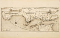
EMBOUCHURE DE LA RIVIERE DU TAGE.: Mouth of the River Tagus.
by FER, Nicolas de.
- Used
- Condition
- Used
- Quantity Available
- 1
- Seller
-
London, United Kingdom
- Item Price
-
SGD 471.93SGD 20.59 shipping to USA
Show Details
Description:
Atlas Curieux ou le Monde., c.1710. The lower half of this attractive engraving shows the mouth of the Tagus from the sea to Lisbon, showing the coastline, settlement and fortification in detail. Title at top centre flanked by two views- To the left, the 'Palais Royal de Lisbonne', and to the right, 'Le Chateau de Belem'. Copper engraving. Uncoloured. Fine condition. Size: 405 x 175 mm. (16 x 7 inches).
Item Price
SGD 471.93
SGD 20.59
shipping to USA

EMPIRE OF JAPAN YEDO.: 112.
by STANFORD, Edward.Engraved by WALKER, J & C.
- Used
- Condition
- Used
- Quantity Available
- 1
- Seller
-
London, United Kingdom
- Item Price
-
SGD 300.32SGD 20.59 shipping to USA
Show Details
Description:
Atlas for the Society for the Diffusion of Useful Knowledge.. A detailed map of Japan with insets of Nagasaki harbour, and the eastern point of the island of Yeso. Scale in right hand margin. Steel engraving. Later colour. Very good condition. Size: 31 x 39 cm. (12 x 15½ inches)
Item Price
SGD 300.32
SGD 20.59
shipping to USA

ENGLAND & WALES.: Plate 13.
by HALL, Sydney.
- Used
- Condition
- Used
- Quantity Available
- 1
- Seller
-
London, United Kingdom
- Item Price
-
SGD 377.54SGD 20.59 shipping to USA
Show Details
Description:
A New General Atlas. Longman, Rees, Brown & Green., 1828.. Attractive late copper engraving of England and Wales. Copper engraving. Original outline colour. Fine condition. Good margins. Size: 44 x 53.5 cm. (17½ x 21 inches)
Item Price
SGD 377.54
SGD 20.59
shipping to USA

ENGLAND II
by Engraved by J & C Walker
- Used
- Condition
- Used
- Quantity Available
- 1
- Seller
-
London, United Kingdom
- Item Price
-
SGD 111.55SGD 20.59 shipping to USA
Show Details
Description:
Society for the Diffusion of Useful Knowledge, London., 1844.. Benevolent societies with the intention to disseminate knowledge were a distinguishing feature of the Victorian age. SDUK was founded in 1827 by John, Earl Russell and Henry Brougham, later Lord Chancellor of England. The Society published books that were deemed to be of high educational worth but with an affordable price. Steel engraving. Original outline colour. Good condition. Size: 37 x 30.5 cm. (14½ x 12 inches)
Item Price
SGD 111.55
SGD 20.59
shipping to USA

ENGLAND.
by CARY, John.
- Used
- Condition
- Used
- Quantity Available
- 1
- Seller
-
London, United Kingdom
- Item Price
-
SGD 248.83SGD 20.59 shipping to USA
Show Details
Description:
New Universal Atlas., 1808.. This beautiful map, accurate and concise, is from John Cary's Universal Atlas. This was a compact version of his General Atlas, and shows the high standard of design, printing, and geographical accuracy that has led many to consider Cary as the finest of English map-makers. Copper engraving. Original colour. Fine condition. Size: 23 x 28 cm. (9 x 11 inches).
Item Price
SGD 248.83
SGD 20.59
shipping to USA
![[ENGLISH CHANNEL].](https://d3525k1ryd2155.cloudfront.net/h/957/207/319207957.0.m.jpg)
[ENGLISH CHANNEL].
by COLLINS, Capt. Greenvile
- Used
- Condition
- Used
- Quantity Available
- 1
- Seller
-
London, United Kingdom
- Item Price
-
SGD 943.86SGD 20.59 shipping to USA
Show Details
Description:
London., c1760. A detailed sea chart of the northern part of the English channel, from Kent to Norfolk, from Calais to Frisland, showing sandbanks, soundings, rhumb lines. There is a dedicatory cartouche at lower right on sea shell held aloft by sea nymphs. Captain Greenvile Collins was an outstanding naval officer who became 'Hydrographer to the King' before the Coasting Pilot was published. 'The Coasting Pilot' atlas was the result of the first systematic survey of British coastal waters. It took eight years to complete. The work proved to be extremely popular, and was reissued many times over a number of years. The charts are notable for both their accuracy and their charm. (Ref Tooley, Dictionary of Maps and Map Makers p.125; Moreland & Bannister, Antique Maps p.163). Size: 570 x 445 mm. Copper engraving. Later colour. Expert repairs to margins Very good condition Tooley, Dictionary of Maps and Map Makers p.125; Moreland & Bannister, Antique Maps p.163
Item Price
SGD 943.86
SGD 20.59
shipping to USA

ESPAGNE.
by SANSON, Nicolas.
- Used
- Condition
- Used
- Quantity Available
- 1
- Seller
-
London, United Kingdom
- Item Price
-
SGD 334.64SGD 20.59 shipping to USA
Show Details
Description:
Nicolas Bion: L'Usage des Globes. Amsterdam: Francois Halma., 1700. Attractive map of Spain, divided into its provinces. Maps by Sanson in original colour are rare. Nicolas Sanson was founder of the French school of mapmakers, at a time when the leadership in European cartography passed from the Low Countries to France. This map was published in Brion's treatise on globes. Nicolas Brion was a famous French mathematical and scientific instrument maker. Copper engraving. Original colour. Fine condition. Size: 23.5 x 18 cm. (9½ x 7 inches).
Item Price
SGD 334.64
SGD 20.59
shipping to USA

Didn’t find what you’re looking for?
Try adding this search to your want list. Millions of books are added to our site everyday and when we find one that matches your search, we’ll send you an email. Best of all, it’s free.
Add to Want List

Are you a frequent reader or book collector?
Join the Bibliophile's Club and save 10% on every purchase, every day — up to $20 savings per order!

Social Responsibility
Did you know that since 2004, Biblio has used its profits to build 16 public libraries in rural villages of South America?
