Description:
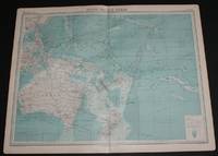
The Times, London, 1920. First Edition. Softcover. Very Good Condition/No Dust Jacket. Disbound single sheet with vertical centre fold from the 1920 "The Times Survey Atlas of the World". Map is in colour and sheet is suitable for framing. Land is coloured grey and sea is shades of blue according to depth. Map contains major currents/streams and directions are indicated by small arrows. Key shipping routes are marked. Mapped area includes; South Pacific Ocean, North and South Equatorial Currents, Equatorial Counter Current, Micronesia, Melanesia and Oceania, Australia, Tasmania, Hawaii, Papua New Guinea, Philippines, New Zealand, Fiji, Tonga, New Hebrides, Caroline Islands, East Indian Archipelago, Marquesas Islands, Chatham Island, Tuamotu or Low Archipelago, Lin Kin Islands, Magelhaes Archipelago, Soloman Islands, Bismark Archipelago, etc. Sheet has slightly darkened edges with occasional light foxing in the margins and edges of the mapped area. Sheet is otherwise clean and bright.…
Read More Search Results: pacific ocean atlas plate
You searched for:
- Title: pacific ocean atlas plate
Results 1 - 1 of 1
More Photos
Map of South Pacific Ocean from the 1920 Times Atlas (Plate 102) including Australia, Hawaii, Papua New Guinea, Philippines, New Zealand, Fiji, Tonga, New Hebrides, Caroline Islands, East Indian Archipelago, Marquesas Islands, etc
by The Times and J. G. Bartholomew
- Used
- Paperback
- first
- Condition
- Used - Very Good Condition
- Edition
- First Edition
- Binding
- Paperback
- Quantity Available
- 1
- Seller
-
Doncaster, Aberdeen, United Kingdom
- Item Price
-
SGD 41.74SGD 25.22 shipping to USA
Show Details
Item Price
SGD 41.74
SGD 25.22
shipping to USA

Didn’t find what you’re looking for?
Try adding this search to your want list. Millions of books are added to our site everyday and when we find one that matches your search, we’ll send you an email. Best of all, it’s free.
Add to Want List

Are you a frequent reader or book collector?
Join the Bibliophile's Club and save 10% on every purchase, every day — up to $20 savings per order!

Social Responsibility
Did you know that since 2004, Biblio has used its profits to build 16 public libraries in rural villages of South America?
