Antiquarian Map-South America from Webster's Fine Books & Maps, ABAC, ILAB
New Arrivals

South America Bolivia And Peru With A Part Of Brazil Sheet Vi
by [S.D.U.K.] Walker, J & C.
- Condition
- Used - Slightly toned, small tears lower right corner, but overall very good
- Published
- c. 1849
- Binding
- Copperplate engraving
- Quantity Available
- 1
- Seller
-
Port Hope, Ontario, CAN
- Item Price
-
SGD 68.21
Show Details
Description:
A detailed map of of Peru, Bolivia and Brazil. Bolivia gained its independence from Spain in 1825. Ports, towns, cities and mountain ranges are shown.
Item Price
SGD 68.21

SOUTH AMERICA ECUADOR, GRANADA, VENEZUELA AND PARTS OF BRAZIL AND GUYANA SHEET I
by [S.D.U.K.] Walker, J & C.
- Condition
- Used - Slightly toned but overall very good
- Published
- c. 1849
- Quantity Available
- 1
- Seller
-
Port Hope, Ontario, CAN
- Item Price
-
SGD 75.03
Show Details
Description:
A detailed map of Ecuador, Colombia, Venezuela, Guyana and Northern Brazil. Ports, towns, cities and ancient and topographical features are shown.
Item Price
SGD 75.03
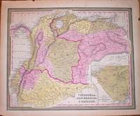
VENEZUELA, NEW GRENADA & EQUADOR
by Mitchell, Samuel Augustus/Cowperthwait, Thomas
- Condition
- Used - Minor chips to margins else very good
- Published
- c. 1846
- Binding
- Copperengraving with full hand colouring
- Quantity Available
- 1
- Seller
-
Port Hope, Ontario, CAN
- Item Price
-
SGD 136.42
Show Details
Description:
detailed map of Venezuela, Colombia and Equador. Inset map of proposed communication i.e. a railroad between the Atlantic and Pacific Ocean.
Item Price
SGD 136.42
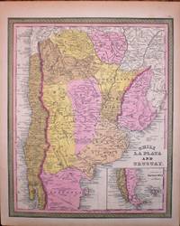
CHILI LA PLATA AND URUGUAY
by Mitchell, Samuel Augustus/Cowperthwait, Thomas
- Condition
- Used - Some minor chips to margins else very good
- Published
- c. 1849
- Binding
- Copperengraved map with full hand colouring
- Quantity Available
- 1
- Seller
-
Port Hope, Ontario, CAN
- Item Price
-
SGD 170.52
Show Details
Description:
A detailed map of Chile, Uruguay and Argentina. Inset map of the tip of Patagonia.
Item Price
SGD 170.52

AMERIQUE MERIDIONALE
by Bellin, Jacques Nicolas
- Condition
- Used
- Published
- 1757
- Quantity Available
- 1
- Seller
-
Port Hope, Ontario, CAN
- Item Price
-
SGD 163.70
Show Details
Description:
From "Histoire Generale des Voyages": Paris, , 1757. 7-3/4" x 16"- 19.6 x 15.2 cm. Copper engraved map hand coloured in outline. Small closed tear right margin, else very good. A small map of South America including mountain ranges, towns, ports and the Amazon River. Item Price
SGD 163.70
MAP OF SOUTH AMERICA. SHOWING ITS POLITICAL DIVISIONS. 1860
by Mitchell, Samuel Augustus
- Condition
- Used
- Published
- 1863
- Quantity Available
- 1
- Seller
-
Port Hope, Ontario, CAN
- Item Price
-
SGD 115.96
Show Details
Description:
Philadelphia: : S. Augustus Mitchell, , 1863. 13-1/2" x 11-1/2" - 34.2 x 29.2 cm. Lithograph with original hand colouring. Minor chips and browning to margins, else very good. A detailed and decorative map of all of South America with scrolling foliate border. Shows towns, cities, ports, and railroad lines. An inset map of the Proposed "Atrato-Inter-Oceanic" Canal… Read more about this item Item Price
SGD 115.96
AMERIQUE MERIDIONALE
by Bellin, Jacques Nicolas
- Condition
- Used
- Published
- 1757
- Quantity Available
- 1
- Seller
-
Port Hope, Ontario, CAN
- Item Price
-
SGD 163.70
Show Details
Description:
From "Histoire Generale des Voyages": Paris, , 1757. 7-3/4" x 16"- 19.6 x 15.2 cm. Copper engraved map. Small closed tear right margin, else very good. A small map of South America including mountain ranges, towns, ports and the Amazon River. Item Price
SGD 163.70
