Description:
Augsburg: Seutter, 1740. VG+, copperplate engraving with original hand coloring (color similar to Homann, with whom Seutter apprenticed before going out on his own in about 1707). There is minimal right marginal soling, but the image and color are exceptionally bright. Decorative cartouche, as usual, probably an allegorical representation of imperial Russia. The map measures 19.25x22.5 inches. .
A. E. S. Road Map U. S. Zone Germany 1947 (40-1/2 x 34 inch) by U. S. Army - 1947
by U. S. Army

A. E. S. Road Map U. S. Zone Germany 1947 (40-1/2 x 34 inch)
by U. S. Army
- Used
- very good
- Paperback
Engineer Base Plant, 1947 Map. Very Good. Loosely Bound Soft Cover. Rare two-sided U. S. Army map with additional information on the other side. (40-1/2 x 34 inch). Some corner creases otherwise very good..
-
Bookseller
Rose City Books
 (US)
(US)
- Format/Binding Paperback
- Book Condition Used - Very Good
- Jacket Condition No Jacket
- Binding Paperback
- Publisher Engineer Base Plant
- Date Published 1947

(Map of Caspian Sea & Environs): Nova et Accuratissima Maris Caspii...petri Alexii Filii. Magni Russorum Emper
by Seutter, GM
- Used
- Condition
- Used
- Binding
- Unknown
- Quantity Available
- 1
- Seller
-
Crozet, Virginia, United States
- Item Price
-
SGD 758.28
Show Details
Item Price
SGD 758.28

(Map of Eastern America and Atlantic Ocean): Carte De L'Ocean Occidental et Partie De L'Amerique Septentrionale..Charlevoix..fait En 1720
by Bellin, Jacques Nicolas
- Used
- Condition
- Used
- Binding
- Unknown
- Quantity Available
- 1
- Seller
-
Crozet, Virginia, United States
- Item Price
-
SGD 668.67
Show Details
Description:
Paris: Ganeau, 1744. Excellent condition, strong impression, b&w engraved copperplate from Tome III of the 4to, 1744 edition of Charlevoix's "Histoire de la Nouvelle France" (Journal D'un Voyage...). The image is 9.5 x 14.5 inches, with folds as issued. This image has the full eastern USA, including Louisiane, north to Newfoundland, most of the Great Lakes, teh Atlantic Ocean, Acores, and east to the western coasts of Africa, Spain, France and British Isles. It is quite attractive, and not often seen for sale in this early state..
Item Price
SGD 668.67

More Photos
GEOGRAPHIA CLASSICA Geography of the Ancients 1723: Described as it is Contained in the Greek and Latin Classics in Twenty-nine Maps of the Old World
by Herman Moll (See note)
- Used
- Hardcover
- Condition
- Used - Light discolour all prelims,initials front pastedown, ffep. Few maps minor defects,Condition Good
- Edition
- Fourth edition
- Binding
- Hardcover
- Quantity Available
- 1
- Seller
-
VICTOR HARBOR, South Australia, Australia
- Item Price
-
SGD 856.04
Show Details
Description:
London: Christopher Brown, 1723. Fourth edition. Original Papered board covers.Front cover detached (present). Back attached.. Light discolour all prelims,initials front pastedown, ffep. Few maps minor defects,Condition Good.. Title, Preface, Advert.,Table of Maps, Twenty-nine uncoloured, copper engraved maps laid down hand made paper. (Complete as called for title page) Overalll clean, minor faults (edges, marks, folds, couple with edge tide marks, etc) Above average. Maps: World (folding - includes part of northern Australia)), Trojan War, Ulysses, Voyage of Aeneas (2), 3 world maps single page, Roman Empire (infancy, Youthful, maturity, Julius Caesar) Hannibal, Gallia Vetus (incl part of GB), Baetica, Africa, Europe/Asia/Africa, Ancient Greece, Mediterranean (Lybia), Egypt, Pyrrhus, Demetrius, Sparta, Defeat 10,000 Greeks, Syria/Assyria, Scriptual Geography, Ecclesiastical History, Cyrus the Great, Persia, Alexander. Rare cartographic publication. National Library Australia lists similar item by…
Read More Item Price
SGD 856.04
More Photos
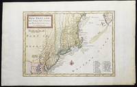
New England, New York, New Jersey, and Pensilvania &c. by H. Moll Geographer
by Moll, Herman
- Used
- near fine
- Condition
- Used - Near Fine
- Binding
- Unknown
- Quantity Available
- 1
- Seller
-
Lansdowne, Pennsylvania, United States
- Item Price
-
SGD 639.72
Show Details
Description:
London: H. Moll, 1708. Near Fine. 1 sheet 232 x 267 mm. (image is 180 x 254 mm.) Hand-colored copper engraved map. This is Herman Moll's earliest map of New England, published in the first edition of John Oldmixon's The British Empire in North America in 1708. List of 19 towns in lower right-hand corner. New Jersey is shown as East New Jersey and West New Jersey. Pennsylvania still contains the Lower Counties, which separated and became Delaware in 1704. On the west side of the Susquehanna River is shown "The Present Sasquahana Indian Fort." In Near Fine Condition: light creasing; clean and bright.
Item Price
SGD 639.72

More Photos
National Route Guide Map (Douchuu Hitori Annaizu)
by ICHIZAEMON, Kichimonjiya
- Used
- near fine
- Condition
- Used - Near Fine
- Quantity Available
- 1
- Seller
-
COLUMBIA, Missouri, United States
- Item Price
-
SGD 687.97
Show Details
Description:
1828 Japanese Illustrated MAP Edo Five Routes Dochu Samurai Woodblock JapanAn interesting 19th century woodblock-print of a map of the Dochu, published in the late modern period when travel to shrines and temples were flourishing for ordinary people. the revised version or the same route by Ichizaemon Kichimonjiya of Yoshimojiya Saemon and Suharaya Shigebe and others "Dochu German Guide Map" or "National Route Guide Map." It is a maze-type road map of the most popular type that is easy to fold and carry. This 'Dochu map' (Guide map) published during the Edo period is printed on both sides with a wooden print on both sides depicting the Edo Five Routes where feudal lords with their samurai had to travel every other year to the capital following these routes. It is quite large measuring at ~101cm x 30cm.
This 19th century edition map includes the names of post towns on the routes with the distance between the towns and the fare for baggage based upon whether it was carried by horse or man!
Item… Read More
Item Price
SGD 687.97

(Map / Chart- Environs of Vienna, Austria): Plan de la Ville De Vienne en Austriche et Ses Environs
by Jaillot, Alexis-Hubert
- Used
- Condition
- Used
- Binding
- Unknown
- Quantity Available
- 1
- Seller
-
Crozet, Virginia, United States
- Item Price
-
SGD 820.33
Show Details
Description:
Paris: Jaillot, 1695. VG, with only flaw some dampstaining at lower margin with expert verso paper reinforcement, not affecting main image (would mat well). Centerfold as issued; hand-colored. A very uncommon and attractive plate, with a small walled city view (birds-eye) of Vienna, with all surrounding villages (castles) marked. A nice image of the Danube is central here. Jaillot was originally a sculptor (see Moreland & Bannister: Antique Maps). The copperplate image is 18x25.5 inches. .
Item Price
SGD 820.33
More Photos
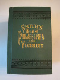
New Map of Philadelphia and Vicinity Published by J. L. Smith, 27 South Sixth St., Philadelphia, 1894 : [Cover title: Smith's Map of Philadelphia and Vicinity]
by Smith, J. L.
- Used
- Hardcover
- first
- Condition
- Used - Fine condition
- Edition
- 1st ed? (No additional printings listed)
- Binding
- Hardcover
- Quantity Available
- 1
- Seller
-
Henderson, Nevada, United States
- Item Price
-
SGD 792.75
Show Details
Description:
Philadelphia: J. L. Smith, 1894. Fine condition. SEE PHOTOS. A very attractive, well preserved copy of this detailed two-part map of Philadelphia and vicinity, published in 1894 (copyright 1893). Tough-to-find in collectible condition as nice as this. A bright, clean copy. NO chips. NO tears. NO creases. NO owner's name or bookplate. Clean and unmarked. Drawn on a scale of 1 inch to the mile. The map consists of two parts. The eastern half unfolds to 23" wide by 27" tall. The western part is 21.5" wide by 27" tall. Both are skillfully and attractively hand colored. The maps are backed in linen, as issued. They are housed in the publisher's original, green cloth portfolio, which is printed in black and embossed in gold on the front cover and in blind on the rear. Gilt lettering is still as bright and shiny as new.. 1st ed? (No additional printings listed). Hardcover. Fine condition.
Item Price
SGD 792.75
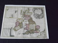
Les Isles Britanniques, qui Contiennent les Royaumes d' Angleterre, Escosse, et Irande…
by Valk, Gerard
- Used
- Condition
- Used
- Quantity Available
- 1
- Seller
-
Florham Park, New Jersey, United States
- Item Price
-
SGD 827.22
Show Details
Description:
Copper engraved, double page, map, hand colored, cartouche uncolored, 49 x 59 cm (19 1/2" x 23"). Some minor soiling and aging; otherwise very good and quite colorful. Valk (1651-1726) was born in Amsterdam, and was also known as Valck. He was a fairly well known engraver and publisher, and would eventually go into partnership with Peter Schenk (1655-1718), and would produce an atlas and maps together. In fact, it seems they brought the property of the Blaeu firm, which gave them material for their maps. This is a very attractive map of Britain, and includes an inset of Orkney, Shetland and Faro islands. The map also contains a large cartouche that depicts angels and Poseidon. Bagrow p. 276.
Item Price
SGD 827.22
More Photos
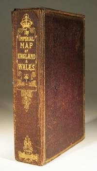
The Imperial Map of England and Wales
- Used
- very good
- Paperback
- Condition
- Used - Very Good
- Binding
- Paperback
- Quantity Available
- 1
- Seller
-
Farningham, Kent, United Kingdom
- Item Price
-
SGD 724.42
Show Details
Description:
London & Edinburgh: A Fullarton & Co The Imperial Map of England and Wales according to the Ordnance Survey, with the latest additions shewing clearly every feature of the country, Railways and their Stations, Roads, Canals, Rivers, Gentlemens Seats etc. on the scale of 4 miles to an inch by John Bartholomew. 19 linen backed sheets numbered 1-15 plus 16 A,B and C. together with a folded index sheet. Flat sheet size, 550x750mm, folded size 275x185mm. All the maps in first class condition with no distress to folds. The folds to the paper index sheet have at some time been rather crudely stregthened. The whole enclosed in the original leathered covered box with an envelope style lid.
Item Price
SGD 724.42

More Photos
RAND MCNALLY & CO'S INDEXED COUNTY AND RAILROAD POCKET MAP AND SHIPPERS' GUIDE OF PENNSYLVANIA ACCOMPANIED BY.....COMPILATION AND READY REFERENCE INDEX SHOWING ENTIRE RAILROAD SYSTEM
by Rand McNally
- Used
- very good
- Hardcover
- first
- Condition
- Used - Very Good
- Edition
- First Edition
- Binding
- Hardcover
- Quantity Available
- 1
- Seller
-
Fairfield, New Jersey, United States
- Item Price
-
SGD 620.42
Show Details
Description:
Chcago; New York: Rand McNally & Co.. Very Good. 1888. First Edition. Hardcover. Dark green boards with bright gilt title on front cover. Front endpaper has rand McNally ads: rear endpaper has map mounted onto it. Text is tight, clean & intact. Map measures 39" x 25 1/2" and is in very nice condition except for a few small tears on the folds. Pennsylvania, Map, Railroad. ; Fold out Map; 16mo 6" - 7" tall; 152 pages .
Item Price
SGD 620.42

The Growing Complexity of Sino-Indian Ties
by Pant Ph.D., Dr. Harsh V.; Strategic Studies Institute (U.S.) [Editor]; Lovelace Jr., Douglas C. [Foreword]; Army War College (U.S.) [Producer];
- Used
- Paperback
- Condition
- Used: Good
- Binding
- Paperback
- ISBN 10 / ISBN 13
- 9781584876304 / 1584876301
- Quantity Available
- 1
- Seller
-
HOUSTON, Texas, United States
- Item Price
-
SGD 5.79
Show Details
Description:
Department of the Army, 2015-06-29. Paperback. Used: Good.
Item Price
SGD 5.79
The Growing Complexity of Sino-Indian Ties
by Pant Ph.D., Dr. Harsh V.; Strategic Studies Institute (U.S.) [Editor]; Lovelace Jr., Douglas C. [Foreword]; Army War College (U.S.) [Producer];
- Used
- Paperback
- Condition
- Used:Good
- Binding
- Paperback
- ISBN 10 / ISBN 13
- 9781584876304 / 1584876301
- Quantity Available
- 1
- Seller
-
HOUSTON, Texas, United States
- Item Price
-
SGD 5.79
Show Details
Description:
Department of the Army, 2015-06-29. Paperback. Used:Good.
Item Price
SGD 5.79
U S Army Survival Manual: FM 21-76
by U.S. Department of the Army
- Used
- Condition
- UsedGood
- ISBN 10 / ISBN 13
- 9780760723142 / 0760723141
- Quantity Available
- 1
- Seller
-
Imperial, Missouri, United States
- Item Price
-
SGD 6.08
Show Details
Description:
UsedGood. The item shows wear from consistent use, but it remains in good condition and works perfectly. All pages and cover are intact (including the dust cover, if applicable). Spine may show signs of wear. Pages may include limited notes and highlighting. May NOT include discs, access code or other supplemental materials.
Item Price
SGD 6.08

Stock Photo: Cover May Be Different
Back to Serve: Return of a Soldier
by U.S. Army (Ret.), CW3 Cesare Giannetti
- Used
- Paperback
- Condition
- Like New
- Binding
- Paperback
- ISBN 10 / ISBN 13
- 9781981653287 / 1981653287
- Quantity Available
- 2
- Seller
-
Chicago, Illinois, United States
- Item Price
-
SGD 2.29
Show Details
Description:
CreateSpace Independent Publishi, 2018-05-02. Paperback. Like New. 0.5300 in x 8.5000 in x 5.5000 in.
Item Price
SGD 2.29

Stock Photo: Cover May Be Different
Survival : How Being Prepared Can Keep You and Your Family Safe
by Honoré (U.S. Army, Lt. Russel
- Used
- Condition
- Used - Very Good
- ISBN 10 / ISBN 13
- 9781416599012 / 1416599010
- Quantity Available
- 1
- Seller
-
Mishawaka, Indiana, United States
- Item Price
-
SGD 6.89
Show Details
Description:
Atria Books. Used - Very Good. Used book that is in excellent condition. May show signs of wear or have minor defects.
Item Price
SGD 6.89

Stock Photo: Cover May Be Different
Quality Assurance Representative's Guide: General Information and Sitework: Vol 1
by Department of Army: U.S. Army Corps of E (Creator)
- Used
- good
- Paperback
- Condition
- Used - Good
- Binding
- Paperback
- ISBN 10 / ISBN 13
- 9781288776399 / 128877639X
- Quantity Available
- 1
- Seller
-
HOUSTON, Texas, United States
- Item Price
-
SGD 7.00
Show Details
Description:
BiblioGov, 2013-02-14. Paperback. Good.
Item Price
SGD 7.00

Stock Photo: Cover May Be Different
ROTARY WING FLIGHT TM 1-260
by U.S. DEPARTMENT OF ARMY (Creator)
- Used
- good
- Paperback
- Condition
- Used - Good
- Binding
- Paperback
- ISBN 10 / ISBN 13
- 9781245565448 / 1245565443
- Quantity Available
- 1
- Seller
-
HOUSTON, Texas, United States
- Item Price
-
SGD 7.10
Show Details
Description:
Nabu Press, 2011-09-15. Paperback. Good.
Item Price
SGD 7.10
De facto Pathfinder
by U.S. Army (Ret.), CW3 Cesare Giannetti
- Used
- good
- Condition
- Used - Good
- ISBN 10 / ISBN 13
- 9781726868921 / 1726868923
- Quantity Available
- 1
- Seller
-
Philadelphia, Pennsylvania, United States
- Item Price
-
SGD 7.10
Show Details
Description:
Independently published. Good. Good. Ship within 24hrs. Satisfaction 100% guaranteed. APO/FPO addresses supported
Item Price
SGD 7.10

Stock Photo: Cover May Be Different
Operational Lessons Learned in the Korean War
by U.S. Army Command and General Staff College
- Used
- Paperback
- Condition
- Used:Good
- Binding
- Paperback
- ISBN 10 / ISBN 13
- 9781500798192 / 1500798193
- Quantity Available
- 1
- Seller
-
HOUSTON, Texas, United States
- Item Price
-
SGD 7.17
Show Details
Description:
CreateSpace Independent Publishing Platform, 2014-08-11. Paperback. Used:Good.
Item Price
SGD 7.17
Introduction to Leadership, MSL I, Revised Edition (BOLC I: Army ROTC)
by U. S. Army
- Used
- good
- Paperback
- Condition
- Used - Good
- Binding
- Paperback
- ISBN 10 / ISBN 13
- 9780536563170 / 0536563179
- Quantity Available
- 1
- Seller
-
Houston, Texas, United States
- Item Price
-
SGD 7.20
Show Details
Description:
Pearson Custom, 2009-01-01. paperback. Good. 8x5x0.
Item Price
SGD 7.20

More Photos
The Sky and the Forest
by Forester, C.S
- Used
- very good
- Hardcover
- first
- Condition
- Used - Very Good
- Jacket Condition
- Very Good
- Edition
- First Edition
- Binding
- Hardcover
- Quantity Available
- 1
- Seller
-
Salem, Oregon, United States
- Item Price
-
SGD 48.10SGD 28.86Save SGD 13.96!
Show Details
Description:
C.S. Forester: The Sky and the Forest. Little, Brown and Company, Boston. Stated First Edition First Printing Thus August, 1948. Cover price $2.75. Used. VG BOOK/VG UNCLIPPED DUST JACKET. A story of a central Africa. By C.S. Forester, author of the Admiral Hornblower series.
Item Price
SGD 48.10SGD 28.86
Save SGD 13.96
!
![Alaska and Klondike Region; [With inset of Klondike Region on the Upper Yukon detail] [From an...](https://d3525k1ryd2155.cloudfront.net/h/062/537/1339537062.0.m.jpg)
Alaska and Klondike Region; [With inset of Klondike Region on the Upper Yukon detail] [From an atlas, "Gazetteer of Alaska and Yukon Region " pp. 105 and 106]
by Miller, J. Martin
- Used
- very good
- Condition
- Used - Very Good
- Edition
- Unknown
- Quantity Available
- 1
- Seller
-
Sebastopol, California, United States
- Item Price
-
SGD 53.77
Show Details
Description:
Chicago: J. Martin Miller, 1899. Unknown. Map. Very Good. [Map copyright 1899, printing date of Atlas later] [19.875x15.125in]; Colored map of Alaska with steamer routes from Portland and Seattle, insets of the Klondike Region on the Upper Yukon and Western portion of Aleutian Islands; On verso index of places and names with two large black and white images; Age toning to all edges, water stain marks on bottom, slight printing offset of colors, small chips and closed tears to lower edge;.
Item Price
SGD 53.77

Zemepis Sveta - Monsunova Asie
by De La Blache, P. Vidal; Gallois, L
- Used
- Hardcover
- Condition
- Used - Very Good Condition
- Jacket Condition
- No Dust Jacket
- Binding
- Hardcover
- Quantity Available
- 1
- Seller
-
Oak Point, Texas, United States
- Item Price
-
SGD 82.72
Show Details
Description:
Aventinum, Prague, Czechoslovakia, 1930. Hardcover. Very Good Condition/No Dust Jacket. Text entirely in Czech. Geography book on Asia with numerous photographs and maps. 1931 edition also available. Size: 4mo - over 9 3/4" - 12" tall. 400 pp. Pages are yellowed, but are tight and clean. Moderate shelfwear along the spine. Corners are lightly bumped. Quantity Available: 1. Shipped Weight: 3-5 pounds. Category: Travel & Places; Non-English Language::Czech; Pictures of this item not already displayed here available upon request. Inventory No: 001227. . Additional shipping charges may apply.
Item Price
SGD 82.72

Zemepis Sveta - Monsunova Asie
by De La Blache, P. Vidal; Gallois, L
- Used
- Hardcover
- Condition
- Used - Very Good Condition
- Jacket Condition
- No Dust Jacket
- Binding
- Hardcover
- Quantity Available
- 1
- Seller
-
Oak Point, Texas, United States
- Item Price
-
SGD 82.72
Show Details
Description:
Aventinum, Prague, Czechoslovakia, 1931. Hardcover. Very Good Condition/No Dust Jacket. Text entirely in Czech. Geography book on Asia with numerous photographs and maps. 1930 edition also available. Size: 4mo - over 9 3/4" - 12" tall. 400 pp. Pages are yellowed, but are tight and clean. Moderate shelfwear along the spine. Corners are lightly bumped. Quantity Available: 1. Shipped Weight: 3-5 pounds. Category: Travel & Places; Non-English Language::Czech; Pictures of this item not already displayed here available upon request. Inventory No: 001228. . Additional shipping charges may apply.
Item Price
SGD 82.72

Asia from the Best Authorities, Russell, ca.1800
by Russell
- Used
- Condition
- Used
- Quantity Available
- 1
- Seller
-
Plymouth, Devon, United Kingdom
- Item Price
-
SGD 34.50
Show Details
Description:
Russell, J. : Asia from the Best Authorities. Nd but ca.1800. From "A New Geographical, Historical and Commercial Grammar and Present State of Several Kingdoms of the World". Copper engraving. Size approx 200 x 230mm. Two neat folds. Some age colouring to edges, otherwise clean and bright. Includes Arabia, India, Borneo, Japan, China and eastern Russia.
Item Price
SGD 34.50

North America from the Best Authorities, Russell, ca.1800
by Russell
- Used
- Condition
- Used
- Quantity Available
- 1
- Seller
-
Plymouth, Devon, United Kingdom
- Item Price
-
SGD 34.50
Show Details
Description:
Russell, J. : A General Map of North America from the Best Authorities. Nd but ca.1800. From "A New Geographical, Historical and Commercial Grammar and Present State of Several Kingdoms of the World." Copper engraving. Size approx 200 x 230mm. Two neat folds. Some age colouring to edges, otherwise very clean and bright.
Item Price
SGD 34.50
![MAP OF UTAH [Territory]](https://d3525k1ryd2155.cloudfront.net/h/836/461/1485461836.0.m.jpg)
More Photos
MAP OF UTAH [Territory]
- Used
- Condition
- Used - Very Good-
- Edition
- Original
- Quantity Available
- 1
- Seller
-
Williamsburg, Virginia, United States
- Item Price
-
SGD 89.62
Show Details
Description:
New York, Richmond, Chicago, & Toledo: H. H. Hardesty, 1885. Original color lithographed map printed by Rand, McNally & Company, Engravers and published in HARDESTY'S HISTORICAL AND GEOGRAPHICAL ENCYCLOPEDIA: SPECIAL VIRGINIA EDITION. 19 3/8 inches by 13 1/4 inches on a 21" X 14 1/2" sheet. The map depicts the Territory of Utah in its final form--large areas had been removed and ceded to Nevada, Colorado, Wyoming, and Nebraska since Utah became a U. S. Territory in 1850. The issue of polygamy prevented statehood until it was finally granted in 1896. This map features railroads and topography and uses color to set off counties from each other. Unlike most atlas maps of the period, this map identifies most small towns. The map is guaranteed to be moe than 135 years old. The map is in about very good condition: generally clean and bright, with slight toning of paper and one faint water stain near the center-left edge of the map.. Original. Single Sheet. Very Good-. Elephant…
Read More Item Price
SGD 89.62

Philips Special Map of the Nile, The Advance on Khartum and the Environs of Omdurman. Cc1900
by George Philips and Son,
- Used
- Condition
- Used
- Quantity Available
- 1
- Seller
-
Plymouth, Devon, United Kingdom
- Item Price
-
SGD 44.84
Show Details
Description:
Philips Special map of the Nile illustrating the Advance on Khartum [Khartoum] with an enlargement of the environs of Omdurman [Omdur]. George Philips and Son, London and Liverpool Ca 1900. 580mm x 900mm folded map. Front title wrapper has come loose, not affecting map area. Three maps are displayed within the sheet. Map1. Map of the Nile Valley 520mm x 300mm showing the approaches of Khartum. Scale 1inch to 100 Geographical miles. Coloured indicating Possessions and Protectorates of European Powers. Map 2. Special map of the Nile from Dongola to Khartum. Scale 16 miles to the inch. Coloured. In set in this map is Map3. Environs of Omdurman, Scale 5 statute miles to the inch. Some small breaks at some folds, not affecting imagery or use of map. Title label is damaged, the map is clean and bright, probably unused. A very interesting record.
Item Price
SGD 44.84

Last Tales
by Dinesen, Isak
- Used
- very good
- Hardcover
- first
- Condition
- Used - Very Good
- Jacket Condition
- Good+
- Edition
- First Edition
- Binding
- Hardcover
- Quantity Available
- 1
- Seller
-
Salem, Oregon, United States
- Item Price
-
SGD 165.44SGD 99.27Save SGD 48.00!
Show Details
Description:
Dinesen, Isak: Last Tales, A Collection of Twelve New Tales of Compelling Beauty 1957, Random House. First Edition. Stated First Printing Thus. Used. Very Good/Good+ original red dust jacket, price-clipped. Jacket states 11/57 on front flap. 5 3/4 X
Item Price
SGD 165.44SGD 99.27
Save SGD 48.00
!

The Adventure of Wrangel Island
by Vilhjalmur Stefansson
- Used
- good
- Hardcover
- first
- Condition
- Used - Good
- Jacket Condition
- No DJ Included
- Edition
- First Edition
- Binding
- Hardcover
- Quantity Available
- 1
- Seller
-
Salem, Oregon, United States
- Item Price
-
SGD 172.19SGD 103.31Save SGD 49.96!
Show Details
Description:
The Adventure of Wrangel Island, Alaska (1925 Macmillan 1st Edition) HISTORY OF ALASKA. EXLIB. Good Condition/ No DJ included. Fold-out map affixed to binding at the back of the book has never been opened. The story of the (unsuccessful) attempted colonization of Wrangel Island Alaska. 413 pages plus appendix, Index. Titling is still bright. A clean, solid copy. Scarce.
Item Price
SGD 172.19SGD 103.31
Save SGD 49.96
!