Description:
Paris: C.N.R.S., 1959. Livre. Bon. En Feuilles. Grand In-folio. Paris, Centre national de la recherche scientifique (CNRS), Editions géographiques de France, sd [1959]. 50 x 32 cm, grand in-folio, 4 ff. + 80 cartes à doubles page réhaussées de couleurs légendées au recto, en feuilles sous portefeuille vert de l'éditeur. Nouvelle et meilleure édition de ce rare atlas, fruit de 30 années de recherches scientifiques. Déchirures au portefeuille, dont le premier plat est détaché, tampons de la bibliothèque d'un lycée sur la page de titre et au recto de chaque planche, sinon un bon exemplaire..
Theatro d'el orbe de la Tierra by ORTELIUS, Abraham (1527-1598)
by ORTELIUS, Abraham (1527-1598)

Theatro d'el orbe de la Tierra
by ORTELIUS, Abraham (1527-1598)
- Used
- Hardcover
- first
Antwerp: Jan Baptist Vrients, 1602. Folio (18 x 12 inches). EXCEPTIONALLY FINE HAND-COLOURED engraved title-page HEIGHTED WITH GOLD, coat of arms of Philip III of Spain by P.A. Schottus, portrait of Ortelius and 149 engraved maps by Frans Hogenberg and others on 120 copperplates and printed on 117 mapsheets, each map richly embellished with figural cartouches, arms, sailing ships, sea monsters, and deities etc (map 21 misbound, rusthole on world map just touching the plate-mark), 120 ten-line woodcut historiated initials, 33 various smaller woodcut initials, all FINELY COLOURED IN A CONTEMPORARY HAND, PROBABLY BY MYNCKEN LIEFRINCKS (TRUUSJE GOEDINGS). Contemporary Spanish paneled vellum over paste-board, each cover finely decorated with gilt filletes, fleurons and and central gilt arabesque, yapp edges, the title in manuscript on the spine, all edges gilt, remains of two pairs of ties (very early and expert repairs to the head and foot of the spine, some minor staining). Modern half green morocco folding-case. Provenance: Otto Schaefer, his sale Sotheby's November 1995, lot 162. AN EXCEPTIONALLY FINE AND ATTRACTIVE COPY OF THE RARE SPANISH EDITION OF ORTELIUS'S "THEATRUM ORBIS TERRARUM" The second edition in Spanish, first published in 1588, and the first edition of the "Theatrum..." published under the imprint of Jan Baptist Vrients, who assumed responsibility for the atlas three years after Ortelius's death. Vrients added several new maps to Ortelius's oeuvre and continued to publish the atlas until his own death in 1612, after which no further editions appeared. This edition of the "Theatrum..." was published without the "Parergon" and the "Nomenclator". The world map used in this edition is printed from Ortelius's third and final "Typus orbis terrarium" plate, which greatly improved the delineation of the southwest coastline of South America and depicted the Solomon Islands for the first time. Also included is the landmark map "America Sive Novi Orbis Nova Descrptio" (America, or New World, Newly Described). Ortelius first published his "Theatrum...", arguably the first atlas in the modern sense of the word in 1570, A businessman native to Antwerp, Ortelius complied the best existing maps, re-engraved them on a standardized format, and included them with the text in one volume. Dedicated to Philip III, King of Spain, who in 1602 ordered an 'armada' to sail from Acapulco on the South coast of Mexico to report on the islands of the Pacific Oceans and the "great realm of California". Truusje Goedings, renowned expert in Dutch colourists of the 17th-century writes of this copy: "The de-luxe colouring of this copy of the Spanish edition has remained remarkably fresh and is of very high quality. It was done by one, contemporary hand in a definitely Flemish style, with its overall colouring in rather heavy, warm hues, though somewhat more refined than usual. The plates and maps are heightened with gold, also in the lettering. Moreover, all initials in the text are coloured brightly and with care and variation. This is rare, and accentuates the quality of the colouring. In general coloured copies of the 'Theatrum' had their texts left plain, and if colour was applied to initials or text-decorations, this was mostly done thin and hastily with just one or two colours. The green used for large land surfaces did not turn into a brownish yellow as often in atlases of this period, but remained fresh in many places. Only a brighter hue, apparently a mixture, has been discoloured. A special feature is the lead white used to whiten the white of the paper (to enhance contrast, or as ground for other colours). In some places this has oxidized and turned into grey, f.e. at the upper part of the dedication print on verso title, and in the cartouche on the Africa map. A de-luxe colouring like this was very costly at the time. Plantijn, former publisher of the 'Theatrum', used to ask especially for these copies expert colourist Myncken Liefrincks, head of the Liefrincks printing firm. As she was still the best address at the time, Vrients will have done the same. Plantijn's archives reveal some of her prices. For instance, for a de-luxe colouring of a Spanish Theatrum (ed. 1588, priced uncoloured ca. fl. 20) with adornments in gold and silver she got payed fl. 36,-, almost four times the price of a regular colouring - and almost twice the price of a plain copy. (see on this my article in Kunst in Kaart, exh. Amsterdam). "The richness of colouring and the carefull overall treatment of this copy suggest it was intended for a wealthy client or for presentation. This Spanish version was Vrients's first edition of the Theatrum after he had bought the plates from Ortelius' heirs, which he dedicated in print to the Spanish king. He certainly had prepared a few copies for presentation to the Spanish court. Where the dedicatee himself in general was presented with a de-luxe binding in leather, one or two of his high-placed favorites who were often also gifted had to do with a little bit less, be it in colour, or in binding (as here might have been the case). Anyhow, the Spanish title and monograms on spine indicate a provenance from an early Spanish owner. Comparison with 2 copies of the same edition held in the Escorial library (see Koeman 31:451, p.212) might bring more light to this". Rijksmuseum 1989, p.95-130, esp. p.113-117, with lit.; and C.Hofmann in Couleur de la Terre, Paris Bibl. Nationale 1999, p.69 ). "All the elements of the modern atlas were brought to publication in Abraham Ortelius' "Theatrum Orbis Terrarum". This substantial undertaking assembled... the best available maps of the world by the most renowned and up-to-date geographers... each of Ortelius' maps was engraved specifically for his atlas according to uniform formats" (Shirley). Ortelius first published his "Theatrum…", arguably the first atlas in the modern sense of the word, in 1570, with 70 seventy copper engravings on fifty-three double-folio pages. A businessman native to Antwerp, Ortelius compiled the best existing maps, re-engraved them on a standardized format, and included them with the text in one volume. But, by 1570, he had been dealing in maps and charts for more than twenty years. The death of Ortelius' father in 1535, who had been a wealthy merchant, seems to have placed his family in financial difficulties. When Ortelius was as young as 19 he is recorded as having joined the Guild of St. Luke as 'afsetter' "or colourist of maps and prints. He seems to have reached a very advanced level of skill in this craft, as some customers continued to insist on buying atlases coloured by him personally at a time when he had already developed into a publisher and cartographer/merchant… Ortelius [also] became a trader in books, prints and maps. Much of this trading had to do with the house of Plantin [subsequently publisher of the 'Theatrum']…Soon he was attending the book fair in Frankfurt to buy and sell books, maps and prints for others as well as for himself. He first met Gerard Mercator there in 1554, which marked the state of a life-long professional relationship and personal friendship… " (van den Broecke page 14). Through his work Ortelius became quite the cosmopolitan, he travelled extensively to France, Germany, Switzerland, Austria, Hungary, Italy, England and Ireland, and as a result had command of several languages. With the publication of the "Theatrum" came tremendous success and wealth. Giving full credit to the original cartographers, the "Theatrum" was so successful that it was printed three times in 1570 alone. In 1574 Ortelius retained the position of Royal Cosmographer to Phillip II and was given a fine gold necklace, worth 1000 ducats. Between 1570 and 1612 the atlas was published in 42 editions and the 7 languages: Latin, German, Flemish, French, Spanish, English and Italian. Koeman Ort 34; Palay 205364; Shirley 158. 1016.4V.4B.Catalogued by Kate Hunter.
-
Bookseller
Arader Galleries
 (US)
(US)
- Book Condition Used
- Binding Hardcover
- Publisher Antwerp: Jan Baptist Vrients, 1602.

More Photos
Atlas de France (métropole)
by Comité national de géographie ; Margerie, Emmanuel de (préf.) ; Perret, Robert (dir.)
- Used
- Paperback
- Condition
- Used - Bon
- Binding
- Paperback
- Quantity Available
- 1
- Seller
-
Paris, France
- Item Price
-
SGD 221.56
Show Details
Item Price
SGD 221.56

More Photos
Le nouveau et curieux Atlas Geographique et historique...
by Chiquet (Jacques) [Antoine Menard].
- Used
- Hardcover
- Condition
- Used
- Binding
- Hardcover
- Quantity Available
- 1
- Seller
-
Sidney, British Columbia, Canada
- Item Price
-
SGD 3,102.08
Show Details
Description:
Paris: chez Chereanau, [1719].. Oblong small 4to. Full vellum with ties. Wear at edges, chip from fore-edge of lower front cover,blank end leaves are heavily annotated and written-upon in 18th & 19th century hands. Old stains to margins and a few maps, old paper-tape repairs to the verso of the Asia map, but generally very good. Engraved allegorical title page, 3 plates (two of globes), and 24 maps opposite explanatory text in French. 23 maps have contemporary hand-colouring in outline; a couple have attractively coloured cartouches. The Globe Terrestre map, of two hemispheres, is holed, slightly affecting the title. The map of North America shows California as an island. This is the second or third edition of this atlas, originally by Antoine Menard, first published by Chiquet in [1711 & 1713], with most of the maps dated 1709-1711. In this 1719 edition Chiquet has removed Menard's name entirely; on many of the maps (such as L'Amerique Septentrionale) he has changed it to his own name and altered…
Read More Item Price
SGD 3,102.08

More Photos
National Route Guide Map (Douchuu Hitori Annaizu)
by ICHIZAEMON, Kichimonjiya
- Used
- near fine
- Condition
- Used - Near Fine
- Quantity Available
- 1
- Seller
-
COLUMBIA, Missouri, United States
- Item Price
-
SGD 687.97
Show Details
Description:
1828 Japanese Illustrated MAP Edo Five Routes Dochu Samurai Woodblock JapanAn interesting 19th century woodblock-print of a map of the Dochu, published in the late modern period when travel to shrines and temples were flourishing for ordinary people. the revised version or the same route by Ichizaemon Kichimonjiya of Yoshimojiya Saemon and Suharaya Shigebe and others "Dochu German Guide Map" or "National Route Guide Map." It is a maze-type road map of the most popular type that is easy to fold and carry. This 'Dochu map' (Guide map) published during the Edo period is printed on both sides with a wooden print on both sides depicting the Edo Five Routes where feudal lords with their samurai had to travel every other year to the capital following these routes. It is quite large measuring at ~101cm x 30cm.
This 19th century edition map includes the names of post towns on the routes with the distance between the towns and the fare for baggage based upon whether it was carried by horse or man!
Item… Read More
Item Price
SGD 687.97

More Photos
抗美援朝時事學習地圖. [Kang Mei yuan Chao shi shi xue xi di tu]. [Current Affairs Study Map - Resisting US Aggression and Aiding Korea].
by [YA XIN CARTOGRAPHIC STUDY SOCIETY].[亞新地學社].
- Used
- first
- Condition
- Used
- Edition
- 1st Edition.
- Binding
- Unknown
- Quantity Available
- 1
- Seller
-
Canberra, Australian Capital Territory, Australia
- Item Price
-
SGD 2,478.02
Show Details
Description:
武昌.[Wuchang].: 亞新地學社.[Ya xin di xue she].. 1st Edition.. August1951.. Large detailed colour Chinese map of Korean War, folded, scale 1:15,000,000, three inset maps on corners, illustrated legend showing agricultural and mining resources lower margin, in original envelope. Some light wear along edges, small holes and wear at folds mended with archival tape, envelope torn with loss mended with archival tape. Inset map 兩個陣營力量對比 "Strength Comparison Between The Two Camps" upper left corner, scale 1: 170,000,000. The Peaceful Camp in red covering the majority of Asia and Europe, a list of 6 countries (Germany, Czech, Hungary, Romania, Bulgaria, Albania) are numbered and are also part of the Peaceful Camp. The Invader Camp in grey covering North America and small parts of Europe, a list of 3 nations (Netherlands, Belgium, Luxembourg) are numbered and are also part of the Invader Camp. Block of text in…
Read More Item Price
SGD 2,478.02

More Photos
Arab navigation in the Indian Ocean before the coming of the Portuguese
by Ahmad ibn Majid al-Sadi , G.R. Tibbetts
- Used
- Hardcover
- first
- Condition
- Very Good: Cover some light shelf wear, inside as new
- Edition
- First Edition
- Binding
- Hardcover
- ISBN 10 / ISBN 13
- 9780718909000 / 0718909003
- Quantity Available
- 1
- Seller
-
Berg en dal, Netherlands
- Item Price
-
SGD 354.50
Show Details
Description:
Ahmad ibn Majid al-Sadi, G.R. Tibbetts - Arab Navigation in the Indian Ocean before the coming of the Portuguese - London, The Royal Asiatic Society of Great Britain and Ireland; Luzac and Company Ltd, 1971 - First Edition - Hardcover - 614pp + 4 maps (out of 7)- 22x14 cmCondition Very Good: Cover some light shelf wear, inside as new. Four out of seven maps present: Chart of the Arabian Sea, India and the Bay of Bengal, Red Sea and Gulf of Eden, East African CoastIf you have any questions or want to see more pictures, feel free to ask.Your book will be securely packed and shipped with tracking number, signed & insured.
Item Price
SGD 354.50

(Map / Chart- Environs of Vienna, Austria): Plan de la Ville De Vienne en Austriche et Ses Environs
by Jaillot, Alexis-Hubert
- Used
- Condition
- Used
- Binding
- Unknown
- Quantity Available
- 1
- Seller
-
Crozet, Virginia, United States
- Item Price
-
SGD 820.33
Show Details
Description:
Paris: Jaillot, 1695. VG, with only flaw some dampstaining at lower margin with expert verso paper reinforcement, not affecting main image (would mat well). Centerfold as issued; hand-colored. A very uncommon and attractive plate, with a small walled city view (birds-eye) of Vienna, with all surrounding villages (castles) marked. A nice image of the Danube is central here. Jaillot was originally a sculptor (see Moreland & Bannister: Antique Maps). The copperplate image is 18x25.5 inches. .
Item Price
SGD 820.33

(Map of Holy Land- Canaan): Canaan
by Speed (Speede), John
- Used
- first
- Condition
- Used
- Binding
- Unknown
- Quantity Available
- 1
- Seller
-
Crozet, Virginia, United States
- Item Price
-
SGD 2,061.16
Show Details
Description:
London: Christopher Browne (at the Globe near the West End of St. Pauls Church), 1695. Good, hand colored outlines, This is the Christopher Browne imprint (see Roderick M. Barron's description in his catalogue 33 as to the recent discovery of this imprint, separate from the more commonly reported Bassett and Chiswell 1676 plate), which may be more common than initially thought. Browne published a bit later, and had purchased the Bassett and Chiswell plates, then changed the name on a few of those (of which this plate was one; very few survive), and the date here is approximate. This is a striking image with Jerusalem inset, newly updated and published in the 1676 edition (date approximate) of Speed's " A Prospect of the Most Famous Parts of the World". There is some general browning, with some professional restorations at folds (virtually no image loss), mild upper margin staining (mostly in blank areas) and backed with Japon paper. A custom case was made for this map, after…
Read More Item Price
SGD 2,061.16
More Photos
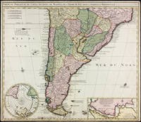
Carte du Paraguay, du Chili, Détroit de Magellan, & Terre de Feu, dans l'Amerique Meridionale par la veuve de Nicholas Visscher
by Visscher, Nicolas
- Used
- Condition
- Used - Margins trimmed but still quite ample, some small marginal stains, a handsome copy.
- Binding
- Unknown
- Quantity Available
- 1
- Seller
-
East Jewett, New York, United States
- Item Price
-
SGD 1,034.02
Show Details
Description:
Amsterdam: Widow of Visscher, 1710. Single sheet copper engraved map, hand-colored. Margins trimmed but still quite ample, some small marginal stains, a handsome copy.. 515 x 595 mm. Strong image of the southern half of South America. Two insets: Carte particuliere de Detroit de Magellan and Circulus Antarcticus. Includes routes of the 18th c. explorers. Rodrigues 2556. Medina: Mapoteca Chilena, p.31, 10a (1740 ed).
Item Price
SGD 1,034.02
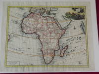
Carta Genererale dell' África.
by Delisle, Guillaume.
- Used
- Condition
- Used
- Quantity Available
- 1
- Seller
-
Florham Park, New Jersey, United States
- Item Price
-
SGD 1,171.90
Show Details
Description:
Double-page hand colored engraved map, 350 x 445 mm (18" x 14", decorative cartouche. Coloring likely done at a later date, but attractively applied, wide margins, very minor aging; a bright and clear impression. Guillaume Delisle (1675-1726) was a French cartographer who was considered one of the best of his age. He has even been referred to as the father of modern geography, and was appointed Premier Geographer to Louis XV in 1718. According to Tooley and Bricker his 1700 map of Africa added a level of accuracy that would hold value for decades to come. This map of Africa is map number 84 in Norwich's Maps of Africa. The coloring was probably done at a later date, but there is an attractive cartouche with several figures, including a man spearing a crocodile. The map is from an Italian edition of Delisle’s Atlante Novissimo. Tooley & Bricker: Landmarks of Mapmaking. Norwich # 84.
Item Price
SGD 1,171.90
![Upper Mines Nos. 1 & 8 [and] Lower Mines No. 3 or Mormon Diggings; [Both on single sheet]...](https://d3525k1ryd2155.cloudfront.net/h/575/126/1453126575.0.m.jpg)
More Photos
Upper Mines Nos. 1 & 8 [and] Lower Mines No. 3 or Mormon Diggings; [Both on single sheet] [included in 30th Congress, Second Session, House, Executive Document No. 1, Message from the President ... James K. Polk, December 5 1848]
by Mason, Richard B. [James K. Polk]
- Used
- very good
- first
- Condition
- Used - Very Good
- Edition
- First Edition
- Binding
- Unknown
- Quantity Available
- 1
- Seller
-
Sebastopol, California, United States
- Item Price
-
SGD 540.45
Show Details
Description:
Washington DC: Government Printing Office, 1848. First Edition. Very Good. [Sheet 10.5x8.25in, Neat line Upper 4.75x6.25in and Lower 4.125x6.25in]; The map shows the location of the Upper Mines Nos. 1 & 8 diggings along the South Fork of the American river, with roads buildings, including Shutter's Saw Mill and Marshall's house and distance to Sutters [Fort]. The Lower Mines No.3 or Mormon Diggings are also along the river and shows the Mormon Bar and labels the gold deposits, the store and road to Sutters. [Wheat Maps 52, Poore p. 567]. Richard Barnes Mason (1797-1850) was a United States Army officer and the fifth Military Governor of California (1847-1849). After gold was discovered by James Marshall at Sutter's Mill in January 1848, General Mason toured the Gold diggings along the American River north east of Sacramento in June, 1848. The report was written in Monterey in August 17, 1848. The Mason reports and maps were part of a larger Federal report to Congress on a number of subjects that…
Read More Item Price
SGD 540.45

Poitou. " "Pictavia
by Ortelius, Abraham
- Used
- first
- Condition
- Used
- Quantity Available
- 1
- Seller
-
Nafplion, Greece
- Item Price
-
SGD 44.31
Show Details
Description:
Europe: Antwerp Joannem Bapt. Vrientium/ Vrients. 1601. Copper engraved minature map by Phillip Galle of Poitou/ Poitiers, Western France, from" Epitome theatri Orteliani praecipuarum orbis regionum delinaetiones. . Editio ultima" Latin text to verso, describing the succeeding map. . Dark impression; overall toning; light foxing/staining to blank margins. The first edition of the"Epitome" in 1577, a reduced format atlas, with minature maps of Abraham Ortelius's "Theatrum" is believed to have been the initiative of the engraver Phillip Galle who asked Peter Heyns to write the text. Ortelius had fled to England in 1576 having taken refuge there from Spanish oppression, and may have been unaware of the plan of his two friends. The pocket atlas was a a commmercial success and was reprinted several times with Galle adding many new maps, and replacing some. Jan. Baptist, Vrients bought the rights and plates of the Epitome from Phillip Galle in 1601, . he published 4 editions using the Galle plates of…
Read More Item Price
SGD 44.31

Picardia. "
by Ortelius, Abraham
- Used
- first
- Condition
- Used
- Quantity Available
- 1
- Seller
-
Nafplion, Greece
- Item Price
-
SGD 44.31
Show Details
Description:
Europe: Antwerp Joannem Bapt. Vrientium/ Vrients. 1601. Copper engraved minature map by Phillip Galle of Picardy, France, from" Epitome theatri Orteliani praecipuarum orbis regionum delinaetiones. . Editio ultima" Latin text to verso, describing the succeeding map. . Dark impression; overall toning; light foxing/staining to blank margins. The first edition of the"Epitome" in 1577, a reduced format atlas, with minature maps of Abraham Ortelius's "Theatrum" is believed to have been the initiative of the engraver Phillip Galle who asked Peter Heyns to write the text. Ortelius had fled to England in 1576 having taken refuge there from Spanish oppression, and may have been unaware of the plan of his two friends. The pocket atlas was a a commmercial success and was reprinted several times with Galle adding many new maps, and replacing some. Jan. Baptist, Vrients bought the rights and plates of the Epitome from Phillip Galle in 1601, . he published 4 editions using the Galle plates of which this is the…
Read More Item Price
SGD 44.31
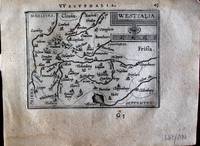
Westfalia. "
by Ortelius, Abraham
- Used
- first
- Condition
- Used
- Quantity Available
- 1
- Seller
-
Nafplion, Greece
- Item Price
-
SGD 44.31
Show Details
Description:
Europe: Antwerp Joannem Bapt. Vrientium/ Vrients. 1601. Copper engraved minature map by Phillip Galle of Westphalia, Germany, from" Epitome theatri Orteliani praecipuarum orbis regionum delinaetiones. . Editio ultima" Latin text to verso, describing the succeeding map. . Dark impression, overall toning, light foxing to blank margins. Light dampstaining to blank margins. The first edition of the"Epitome" in 1577, a reduced format atlas, with minature maps of Abraham Ortelius's "Theatrum" is believed to have been the initiative of the engraver Phillip Galle who asked Peter Heyns to write the text. Ortelius had fled to England in 1576 having taken refuge there from Spanish oppression, and may have been unaware of the plan of his two friends. The pocket atlas was a a commmercial success and was reprinted several times with Galle adding many new maps, and replacing some. Jan. Baptist, Vrients bought the rights and plates of the Epitome from Phillip Galle in 1601, . he published 4 editions using the…
Read More Item Price
SGD 44.31

Blesiense Territorium. "
by Ortelius, Abraham
- Used
- first
- Condition
- Used
- Quantity Available
- 1
- Seller
-
Nafplion, Greece
- Item Price
-
SGD 44.31
Show Details
Description:
Europe: Antwerp Joannem Bapt. Vrientium/ Vrients. 1601. Copper engraved minature map by Phillip Galle of Blois, France, from" Epitome theatri Orteliani praecipuarum orbis regionum delinaetiones. . Editio ultima" Latin text to verso, describing the succeeding map. . Dark impression; overall toning; light foxing/staining to blank margins. The first edition of the"Epitome" in 1577, a reduced format atlas, with minature maps of Abraham Ortelius's "Theatrum" is believed to have been the initiative of the engraver Phillip Galle who asked Peter Heyns to write the text. Ortelius had fled to England in 1576 having taken refuge there from Spanish oppression, and may have been unaware of the plan of his two friends. The pocket atlas was a a commmercial success and was reprinted several times with Galle adding many new maps, and replacing some. Jan. Baptist, Vrients bought the rights and plates of the Epitome from Phillip Galle in 1601, . he published 4 editions using the Galle plates of which this is the…
Read More Item Price
SGD 44.31

Turonensis Ducatus. "
by Ortelius, Abraham
- Used
- first
- Condition
- Used
- Quantity Available
- 1
- Seller
-
Nafplion, Greece
- Item Price
-
SGD 44.31
Show Details
Description:
Europe: Antwerp Joannem Bapt. Vrientium/ Vrients. 1601. Copper engraved minature map by Phillip Galle of Touraine, France, from" Epitome theatri Orteliani praecipuarum orbis regionum delinaetiones. . Editio ultima" Latin text to verso, describing the succeeding map. . Dark impression; overall toning; light foxing/staining to blank margins. The first edition of the"Epitome" in 1577, a reduced format atlas, with minature maps of Abraham Ortelius's "Theatrum" is believed to have been the initiative of the engraver Phillip Galle who asked Peter Heyns to write the text. Ortelius had fled to England in 1576 having taken refuge there from Spanish oppression, and may have been unaware of the plan of his two friends. The pocket atlas was a a commmercial success and was reprinted several times with Galle adding many new maps, and replacing some. Jan. Baptist, Vrients bought the rights and plates of the Epitome from Phillip Galle in 1601, . he published 4 editions using the Galle plates of which this is the…
Read More Item Price
SGD 44.31

Delphinatus. " "Auaicus Principatus
by Ortelius, Abraham
- Used
- first
- Condition
- Used
- Quantity Available
- 1
- Seller
-
Nafplion, Greece
- Item Price
-
SGD 44.31
Show Details
Description:
Europe: Antwerp Joannem Bapt. Vrientium/ Vrients. 1601. Copper engraved minature map by Phillip Galle of Duphiné, France, from" Epitome theatri Orteliani praecipuarum orbis regionum delinaetiones. . Editio ultima" Latin text to verso, describing the succeeding map. . Dark impression; overall toning; light foxing/staining to blank margins. The first edition of the"Epitome" in 1577, a reduced format atlas, with minature maps of Abraham Ortelius's "Theatrum" is believed to have been the initiative of the engraver Phillip Galle who asked Peter Heyns to write the text. Ortelius had fled to England in 1576 having taken refuge there from Spanish oppression, and may have been unaware of the plan of his two friends. The pocket atlas was a a commmercial success and was reprinted several times with Galle adding many new maps, and replacing some. Jan. Baptist, Vrients bought the rights and plates of the Epitome from Phillip Galle in 1601, . he published 4 editions using the Galle plates of which this is the…
Read More Item Price
SGD 44.31

Veromandui. "
by Ortelius, Abraham
- Used
- first
- Condition
- Used
- Quantity Available
- 1
- Seller
-
Nafplion, Greece
- Item Price
-
SGD 44.31
Show Details
Description:
Europe: Antwerp Joannem Bapt. Vrientium/ Vrients. 1601. Copper engraved minature map by Phillip Galle of the area around St. Quentin & Pérrone. known as Vermandois, France, from" Epitome theatri Orteliani praecipuarum orbis regionum delinaetiones. . Editio ultima" Latin text to verso, describing the succeeding map. . Dark impression; overall toning; light foxing/staining to blank margins; printed crooked on the page. heading shaved, and upper margin very short2-6mm. The first edition of the"Epitome" in 1577, a reduced format atlas, with minature maps of Abraham Ortelius's "Theatrum" is believed to have been the initiative of the engraver Phillip Galle who asked Peter Heyns to write the text. Ortelius had fled to England in 1576 having taken refuge there from Spanish oppression, and may have been unaware of the plan of his two friends. The pocket atlas was a a commmercial success and was reprinted several times with Galle adding many new maps, and replacing some. Jan. Baptist, Vrients bought the…
Read More Item Price
SGD 44.31

Aniou. " "Andegavensis Ducatus
by Ortelius, Abraham
- Used
- first
- Condition
- Used
- Quantity Available
- 1
- Seller
-
Nafplion, Greece
- Item Price
-
SGD 44.31
Show Details
Description:
Europe: Antwerp Joannem Bapt. Vrientium/ Vrients. 1601. Copper engraved minature map by Phillip Galle of Anjou, France, from" Epitome theatri Orteliani praecipuarum orbis regionum delinaetiones. . Editio ultima" Latin text to verso, describing the succeeding map. . Dark impression, overall toning, light foxing to blank margins; one darker spot to lower blank margin The first edition of the"Epitome" in 1577, a reduced format atlas, with minature maps of Abraham Ortelius's "Theatrum" is believed to have been the initiative of the engraver Phillip Galle who asked Peter Heyns to write the text. Ortelius had fled to England in 1576 having taken refuge there from Spanish oppression, and may have been unaware of the plan of his two friends. The pocket atlas was a a commmercial success and was reprinted several times with Galle adding many new maps, and replacing some. Jan. Baptist, Vrients bought the rights and plates of the Epitome from Phillip Galle in 1601, . he published 4 editions using the Galle…
Read More Item Price
SGD 44.31

Caletum et Bononia. "
by Ortelius, Abraham
- Used
- first
- Condition
- Used
- Quantity Available
- 1
- Seller
-
Nafplion, Greece
- Item Price
-
SGD 44.31
Show Details
Description:
Europe: Antwerp Joannem Bapt. Vrientium/ Vrients. 1601. Copper engraved minature map by Phillip Galle of the Pas-de Calais, France, from" Epitome theatri Orteliani praecipuarum orbis regionum delinaetiones. . Editio ultima" Latin text to verso, describing the succeeding map. . Dark impression; overall toning; light foxing/staining to blank margins. The first edition of the"Epitome" in 1577, a reduced format atlas, with minature maps of Abraham Ortelius's "Theatrum" is believed to have been the initiative of the engraver Phillip Galle who asked Peter Heyns to write the text. Ortelius had fled to England in 1576 having taken refuge there from Spanish oppression, and may have been unaware of the plan of his two friends. The pocket atlas was a a commmercial success and was reprinted several times with Galle adding many new maps, and replacing some. Jan. Baptist, Vrients bought the rights and plates of the Epitome from Phillip Galle in 1601, . he published 4 editions using the Galle plates of which this…
Read More Item Price
SGD 44.31

Campania. "
by Ortelius, Abraham
- Used
- first
- Condition
- Used
- Quantity Available
- 1
- Seller
-
Nafplion, Greece
- Item Price
-
SGD 44.31
Show Details
Description:
Europe: Antwerp Joannem Bapt. Vrientium/ Vrients. 1601. Copper engraved minature map by Phillip Galle of Champagne, France, from" Epitome theatri Orteliani praecipuarum orbis regionum delinaetiones. . Editio ultima" Latin text to verso, describing the succeeding map. . Dark impression; overall toning; light foxing/staining to blank margins. The first edition of the"Epitome" in 1577, a reduced format atlas, with minature maps of Abraham Ortelius's "Theatrum" is believed to have been the initiative of the engraver Phillip Galle who asked Peter Heyns to write the text. Ortelius had fled to England in 1576 having taken refuge there from Spanish oppression, and may have been unaware of the plan of his two friends. The pocket atlas was a a commmercial success and was reprinted several times with Galle adding many new maps, and replacing some. Jan. Baptist, Vrients bought the rights and plates of the Epitome from Phillip Galle in 1601, . he published 4 editions using the Galle plates of which this is the…
Read More Item Price
SGD 44.31

More Photos
The Sky and the Forest
by Forester, C.S
- Used
- very good
- Hardcover
- first
- Condition
- Used - Very Good
- Jacket Condition
- Very Good
- Edition
- First Edition
- Binding
- Hardcover
- Quantity Available
- 1
- Seller
-
Salem, Oregon, United States
- Item Price
-
SGD 48.10SGD 28.86Save SGD 13.96!
Show Details
Description:
C.S. Forester: The Sky and the Forest. Little, Brown and Company, Boston. Stated First Edition First Printing Thus August, 1948. Cover price $2.75. Used. VG BOOK/VG UNCLIPPED DUST JACKET. A story of a central Africa. By C.S. Forester, author of the Admiral Hornblower series.
Item Price
SGD 48.10SGD 28.86
Save SGD 13.96
!
![Alaska and Klondike Region; [With inset of Klondike Region on the Upper Yukon detail] [From an...](https://d3525k1ryd2155.cloudfront.net/h/062/537/1339537062.0.m.jpg)
Alaska and Klondike Region; [With inset of Klondike Region on the Upper Yukon detail] [From an atlas, "Gazetteer of Alaska and Yukon Region " pp. 105 and 106]
by Miller, J. Martin
- Used
- very good
- Condition
- Used - Very Good
- Edition
- Unknown
- Quantity Available
- 1
- Seller
-
Sebastopol, California, United States
- Item Price
-
SGD 53.77
Show Details
Description:
Chicago: J. Martin Miller, 1899. Unknown. Map. Very Good. [Map copyright 1899, printing date of Atlas later] [19.875x15.125in]; Colored map of Alaska with steamer routes from Portland and Seattle, insets of the Klondike Region on the Upper Yukon and Western portion of Aleutian Islands; On verso index of places and names with two large black and white images; Age toning to all edges, water stain marks on bottom, slight printing offset of colors, small chips and closed tears to lower edge;.
Item Price
SGD 53.77

Zemepis Sveta - Monsunova Asie
by De La Blache, P. Vidal; Gallois, L
- Used
- Hardcover
- Condition
- Used - Very Good Condition
- Jacket Condition
- No Dust Jacket
- Binding
- Hardcover
- Quantity Available
- 1
- Seller
-
Oak Point, Texas, United States
- Item Price
-
SGD 82.72
Show Details
Description:
Aventinum, Prague, Czechoslovakia, 1931. Hardcover. Very Good Condition/No Dust Jacket. Text entirely in Czech. Geography book on Asia with numerous photographs and maps. 1930 edition also available. Size: 4mo - over 9 3/4" - 12" tall. 400 pp. Pages are yellowed, but are tight and clean. Moderate shelfwear along the spine. Corners are lightly bumped. Quantity Available: 1. Shipped Weight: 3-5 pounds. Category: Travel & Places; Non-English Language::Czech; Pictures of this item not already displayed here available upon request. Inventory No: 001228. . Additional shipping charges may apply.
Item Price
SGD 82.72

Zemepis Sveta - Monsunova Asie
by De La Blache, P. Vidal; Gallois, L
- Used
- Hardcover
- Condition
- Used - Very Good Condition
- Jacket Condition
- No Dust Jacket
- Binding
- Hardcover
- Quantity Available
- 1
- Seller
-
Oak Point, Texas, United States
- Item Price
-
SGD 82.72
Show Details
Description:
Aventinum, Prague, Czechoslovakia, 1930. Hardcover. Very Good Condition/No Dust Jacket. Text entirely in Czech. Geography book on Asia with numerous photographs and maps. 1931 edition also available. Size: 4mo - over 9 3/4" - 12" tall. 400 pp. Pages are yellowed, but are tight and clean. Moderate shelfwear along the spine. Corners are lightly bumped. Quantity Available: 1. Shipped Weight: 3-5 pounds. Category: Travel & Places; Non-English Language::Czech; Pictures of this item not already displayed here available upon request. Inventory No: 001227. . Additional shipping charges may apply.
Item Price
SGD 82.72

North America from the Best Authorities, Russell, ca.1800
by Russell
- Used
- Condition
- Used
- Quantity Available
- 1
- Seller
-
Plymouth, Devon, United Kingdom
- Item Price
-
SGD 34.50
Show Details
Description:
Russell, J. : A General Map of North America from the Best Authorities. Nd but ca.1800. From "A New Geographical, Historical and Commercial Grammar and Present State of Several Kingdoms of the World." Copper engraving. Size approx 200 x 230mm. Two neat folds. Some age colouring to edges, otherwise very clean and bright.
Item Price
SGD 34.50

Asia from the Best Authorities, Russell, ca.1800
by Russell
- Used
- Condition
- Used
- Quantity Available
- 1
- Seller
-
Plymouth, Devon, United Kingdom
- Item Price
-
SGD 34.50
Show Details
Description:
Russell, J. : Asia from the Best Authorities. Nd but ca.1800. From "A New Geographical, Historical and Commercial Grammar and Present State of Several Kingdoms of the World". Copper engraving. Size approx 200 x 230mm. Two neat folds. Some age colouring to edges, otherwise clean and bright. Includes Arabia, India, Borneo, Japan, China and eastern Russia.
Item Price
SGD 34.50
![MAP OF UTAH [Territory]](https://d3525k1ryd2155.cloudfront.net/h/836/461/1485461836.0.m.jpg)
More Photos
MAP OF UTAH [Territory]
- Used
- Condition
- Used - Very Good-
- Edition
- Original
- Quantity Available
- 1
- Seller
-
Williamsburg, Virginia, United States
- Item Price
-
SGD 89.62
Show Details
Description:
New York, Richmond, Chicago, & Toledo: H. H. Hardesty, 1885. Original color lithographed map printed by Rand, McNally & Company, Engravers and published in HARDESTY'S HISTORICAL AND GEOGRAPHICAL ENCYCLOPEDIA: SPECIAL VIRGINIA EDITION. 19 3/8 inches by 13 1/4 inches on a 21" X 14 1/2" sheet. The map depicts the Territory of Utah in its final form--large areas had been removed and ceded to Nevada, Colorado, Wyoming, and Nebraska since Utah became a U. S. Territory in 1850. The issue of polygamy prevented statehood until it was finally granted in 1896. This map features railroads and topography and uses color to set off counties from each other. Unlike most atlas maps of the period, this map identifies most small towns. The map is guaranteed to be moe than 135 years old. The map is in about very good condition: generally clean and bright, with slight toning of paper and one faint water stain near the center-left edge of the map.. Original. Single Sheet. Very Good-. Elephant…
Read More Item Price
SGD 89.62

Philips Special Map of the Nile, The Advance on Khartum and the Environs of Omdurman. Cc1900
by George Philips and Son,
- Used
- Condition
- Used
- Quantity Available
- 1
- Seller
-
Plymouth, Devon, United Kingdom
- Item Price
-
SGD 44.84
Show Details
Description:
Philips Special map of the Nile illustrating the Advance on Khartum [Khartoum] with an enlargement of the environs of Omdurman [Omdur]. George Philips and Son, London and Liverpool Ca 1900. 580mm x 900mm folded map. Front title wrapper has come loose, not affecting map area. Three maps are displayed within the sheet. Map1. Map of the Nile Valley 520mm x 300mm showing the approaches of Khartum. Scale 1inch to 100 Geographical miles. Coloured indicating Possessions and Protectorates of European Powers. Map 2. Special map of the Nile from Dongola to Khartum. Scale 16 miles to the inch. Coloured. In set in this map is Map3. Environs of Omdurman, Scale 5 statute miles to the inch. Some small breaks at some folds, not affecting imagery or use of map. Title label is damaged, the map is clean and bright, probably unused. A very interesting record.
Item Price
SGD 44.84

Last Tales
by Dinesen, Isak
- Used
- very good
- Hardcover
- first
- Condition
- Used - Very Good
- Jacket Condition
- Good+
- Edition
- First Edition
- Binding
- Hardcover
- Quantity Available
- 1
- Seller
-
Salem, Oregon, United States
- Item Price
-
SGD 165.44SGD 99.27Save SGD 48.00!
Show Details
Description:
Dinesen, Isak: Last Tales, A Collection of Twelve New Tales of Compelling Beauty 1957, Random House. First Edition. Stated First Printing Thus. Used. Very Good/Good+ original red dust jacket, price-clipped. Jacket states 11/57 on front flap. 5 3/4 X
Item Price
SGD 165.44SGD 99.27
Save SGD 48.00
!

The Adventure of Wrangel Island
by Vilhjalmur Stefansson
- Used
- good
- Hardcover
- first
- Condition
- Used - Good
- Jacket Condition
- No DJ Included
- Edition
- First Edition
- Binding
- Hardcover
- Quantity Available
- 1
- Seller
-
Salem, Oregon, United States
- Item Price
-
SGD 172.19SGD 103.31Save SGD 49.96!
Show Details
Description:
The Adventure of Wrangel Island, Alaska (1925 Macmillan 1st Edition) HISTORY OF ALASKA. EXLIB. Good Condition/ No DJ included. Fold-out map affixed to binding at the back of the book has never been opened. The story of the (unsuccessful) attempted colonization of Wrangel Island Alaska. 413 pages plus appendix, Index. Titling is still bright. A clean, solid copy. Scarce.
Item Price
SGD 172.19SGD 103.31
Save SGD 49.96
!