Description:
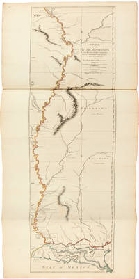
London: Times Newspapers Limited in association with the Royal Geographical Society and David Paradine Developments Limited, 1976.. Limited edition, one of 200 copies, this copy unnumbered. Large folio. (iv), 4 pp. Dark blue half goatskin over marbled boards by Barnard and Jackson, gilt lettered circular label to the upper cover, matching blue cloth slipcase. 30 maps with outline colour, all but one folding or double page. An attractive copy. First published in 1776, this was one of the first major atlases of the Americas. This high quality facsimile was based on the handcoloured copy of the original held by the Royal Geographical Society and was issued to celebrate the 200th Anniversary of the Declaration of Independence. It contains maps of the whole of the Americas but the majority focus on the then known areas of North America.
Search Results: the american atlas
You searched for:
- Title: the american atlas
- Author: jefferys thomas
Results 1 - 6 of 6
![The American Atlas 1776. [Second title, copying the original] The American Atlas: or, a...](https://d3525k1ryd2155.cloudfront.net/h/887/885/1372885887.0.m.jpg)
The American Atlas 1776. [Second title, copying the original] The American Atlas: or, a Geographical Description of the Whole Continent of America: wherein are Delineated at Large, its Several Regions, Countries, States, and Islands; and Chiefly the British Colonies..
by JEFFERYS, Thomas
- Used
- Hardcover
- Condition
- Used
- Binding
- Hardcover
- Quantity Available
- 1
- Seller
-
Lewes, East Sussex, United Kingdom
- Item Price
-
SGD 1,117.35SGD 46.41 shipping to USA
Show Details
Item Price
SGD 1,117.35
SGD 46.41
shipping to USA
![The American Atlas 1776 [with second facsimile title:] The American Atlas: A Geographical...](https://d3525k1ryd2155.cloudfront.net/h/368/446/1588446368.0.m.jpg)
More Photos
The American Atlas 1776 [with second facsimile title:] The American Atlas: A Geographical Description of the Whole Continent of America: Wherein are Delineated at Large, its Several Regions, Countries, States, and Islands; and Chiefly British Colonies..
by Thomas Jefferys
- Used
- near fine
- Condition
- Used - Near Fine
- Quantity Available
- 1
- Seller
-
Washington, District of Columbia, United States
- Item Price
-
SGD 1,369.20SGD 6.16 shipping to USA
Show Details
Description:
London: Times Newspaper Limited in Association with the Royal Geographical Society and David Paradine Developments Limited, 1976. Near Fine. London: Times Newspaper Limited in Association with the Royal Geographical Society and David Paradine Developments Limited, 1976. Limited Edition reprint with a stated print run of 200 numbered copies, though this copy unnumbered. Folio. Unpaginated but with 30 hand-colored numbered maps, many folding or double-paged. Half-bound in dark blue morocco over marbled boards by Barnard and Jackson Limited of London. Housed in publisher's slipcase. Light rubbing to extremities. Binding is sound and pages unmarked. Slipcase shows some light scuffing and front medallion rubbed; minor fraying and edgewear; else sound and stable. A Near Fine copy in a Very Good slipcase.
Item Price
SGD 1,369.20
SGD 6.16
shipping to USA
The American Atlas 1776
by Jefferys, Thomas
- Used
- very good
- Hardcover
- Condition
- Used - Very Good
- Binding
- Hardcover
- Quantity Available
- 1
- Seller
-
Didcot, Oxfordshire, United Kingdom
- Item Price
-
SGD 1,388.09SGD 16.33 shipping to USA
Show Details
Description:
London: Times Newspapers Limited/Royal Geographic Society, 1976. No dust jacket. Hardcover in blue card slipcase. Facsimile. Large, heavy book. Number 47 of a commemorative edition of 200 copies printed on the occasion of the American Bicentennial. Book is hand-numbered on first page of text. Item comprises numerous maps, most of which are fold-out. Minor wear on slipcase. Bound in goatskin on spine and leading corners. Hand-marbled boards. Gilt lettering within a circular leather onlay on front board. A few light scores on onlay. Slight wear on spine ends. Slight wear on lower leading corner of front board. Minor bumping on endpapers. Pages are hand-numbered. Contents are clean and clear throughout. AF. hardcover. Very Good. Used.
Item Price
SGD 1,388.09
SGD 16.33
shipping to USA

More Photos
The American Atlas 1776
by JEFFERYS, THOMAS
- Used
- Hardcover
- first
- Condition
- Used - The American Atlas 1776. One of 200 copies printed, on the occasion of the American Bicentennial, this copy being unnumbered. Fi
- Edition
- Limited
- Binding
- Hardcover
- ISBN 10 / ISBN 13
- 9782811016753 / 2811016759
- Quantity Available
- 1
- Seller
-
Potomac, Maryland, United States
- Item Price
-
SGD 1,711.50FREE shipping to USA
Show Details
Description:
First Deluxe Limited Edition thus. One of 200 copies printed, (this one unnumbered), on the occasion of the American Bicentennial, this copy being unnumbered. A stunning work. Fine in dark blue half-bound goatskin over beautiful hand-marbled boards by Barnard & Jackson, lettered in gilt within a circular leather onlay on the front cover. Presented in a near fine lightly rubbed blue cloth slipcase. Illustrated with 30 hand-colored maps, all but one of which fold-out, and many of which are two pages. Pages are hand-numbered. First published in 1776, this was one of the first major atlases of the Americas.This extremely high quality facsimile was based on the hand colored copy of the original held by the Royal Geographical Society and was issued to celebrate the 200th Anniversary of the Declaration of Independence. The Maps cover the whole of the Americas, but the majority focus on the then known areas of North America. This beautiful copy is quite large and heavy, and may require additional postage.
Item Price
SGD 1,711.50
FREE shipping to USA

More Photos
The American Atlas; or, a Geographical Description of the Whole Continent of America; Wherein are Delineated at Large its Several Regions, Countries, States, and Islands; and Chiefly the British Colonies
by JEFFERYS, Thomas (1719-1771)
- Used
- Condition
- Used
- Quantity Available
- 1
- Seller
-
New York, New York, United States
- Item Price
-
SGD 136,920.00FREE shipping to USA
Show Details
Description:
London: Printed and Sold by R. Sayer and J. Bennett, 1775. Folio. (21 1/4 x 15 1/8 inches). Mounted on guards throughout. Letterpress title and index leaf, otherwise engraved. 22 engraved maps, on 29 sheets (28 folding or double-page), all hand-colored in outline. Expertly bound to style in eighteenth-century half Russia over contemporary marbled boards, the flat spine richly gilt in eight compartments divided by filets, Greek-key and rope-twist roll-tools, lettered in the second, the others with elaborate rococo repeat pattern. "The American Atlas" is the most important 18th-century atlas for America. Ristow describes it as a "geographical description of the whole continent of America, as portrayed in the best available maps in the latter half of the eighteenth century. A major cartographic reference work it was, very likely, consulted by American, English, and French civilian administrators and military officers during the Revolution." As a collection, the American Atlas stands as the most…
Read More Item Price
SGD 136,920.00
FREE shipping to USA
More Photos
THE AMERICAN ATLAS: OR, A GEOGRAPHICAL DESCRIPTION OF THE WHOLE CONTINENT OF AMERICA; WHEREIN ARE DELINEATED AT LARGE ITS SEVERAL REGIONS, COUNTRIES, STATES, AND ISLANDS; AND CHIEFLY THE BRITISH COLONIES...
by Jefferys, Thomas
- Used
- Hardcover
- Condition
- Used
- Binding
- Hardcover
- Quantity Available
- 1
- Seller
-
New Haven, Connecticut, United States
- Item Price
-
SGD 150,612.00SGD 10.95 shipping to USA
Show Details
Description:
London: Printed and sold by R. Sayer and J. Bennett, 1782.. Letterpress title and index leaf, otherwise engraved throughout. Twenty-three engraved maps on thirty-one sheets (eighteen folding, eleven double-page), all handcolored in outline. Antique-style half speckled calf and marbled boards, spine with raised bands, bands and ornaments tooled in gilt, leather label. Titlepage somewhat soiled, early ownership inscription at top. Minor edge wear and edge soiling to some maps; a few minor instances of foxing. A few closed tears, not affecting images, neatly repaired. A handsome, near fine copy. THE AMERICAN ATLAS is the most important 18th-century atlas for America. Walter Ristow describes it as a "geographical description of the whole continent of America, as portrayed in the best available maps in the latter half of the eighteenth century...as a major cartographic reference work it was, very likely, consulted by American, English, and French civilian administrators and military officers during the…
Read More Item Price
SGD 150,612.00
SGD 10.95
shipping to USA

Didn’t find what you’re looking for?
Try adding this search to your want list. Millions of books are added to our site everyday and when we find one that matches your search, we’ll send you an email. Best of all, it’s free.
Add to Want List

Are you a frequent reader or book collector?
Join the Bibliophile's Club and save 10% on every purchase, every day — up to $20 savings per order!

Social Responsibility
Did you know that since 2004, Biblio has used its profits to build 16 public libraries in rural villages of South America?
