Description:
Amsterdam: Mercator/Hondius, 1609. . A copper engraved map on laid paper, uncoloured, from the 1609 German edition of the Mercator/Hondius ATLAS MINOR. Image size is 18cm x 14.5cm, on a sheet measuring 23cm x 18cm (9 x 7 inches). Cartouche at lower right. Text on map is in Latin. Text on verso is German. Page number on verso is 536. Clean, very good condition. A regional map of Italy.
Search Results: Maps from William Matthews, Bookseller / The Haunted Bookshop
You searched for:
- Subject: Maps from William Matthews, Bookseller / The Haunted Bookshop
Results 1 - 20 of 320

More Photos
Abruzzo et Terra di Lovoro
by Mercator (Gerard) & Jodocus Hondius
- Used
- Condition
- Used
- Quantity Available
- 1
- Seller
-
Sidney, British Columbia, Canada
- Item Price
-
SGD 103.40SGD 24.82 shipping to USA
Show Details
Item Price
SGD 103.40
SGD 24.82
shipping to USA
More Photos
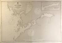
Alaska. Chatham Strait. Bay of Pillars. From the latest United States Government Chart, 1907.
by Alaska Nautical Chart
- Used
- Condition
- Used
- Quantity Available
- 1
- Seller
-
Sidney, British Columbia, Canada
- Item Price
-
SGD 137.87SGD 24.82 shipping to USA
Show Details
Description:
London: British Admiralty, 1908 (1925). . An engraved chart on heavy stock, uncolored, sheet size 40 x 27.5 inches. Published 29th Sept. 1908; Small corrections (printed) to 1925. Original vertical fold, a nice clean copy, a couple of small additions in red pen. In lower right: "Engraved by Weller & Addison". Chart number is 3705. Small typed label on verso giving chart & folio info. Published under the Superintendence of Rear Admiral A. Mostyn Field. Includes an inset map of Washington Bay. Originally published in 1908, this is a printing of 1925.
Item Price
SGD 137.87
SGD 24.82
shipping to USA
More Photos
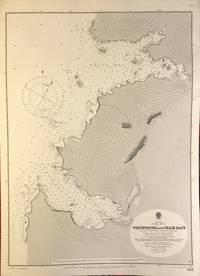
Alaska. Chatham Strait. Whitewater and Chaik Bays. From the United States Government Chart, 1906.
by Alaska Nautical Chart
- Used
- Condition
- Used
- Quantity Available
- 1
- Seller
-
Sidney, British Columbia, Canada
- Item Price
-
SGD 103.40SGD 24.82 shipping to USA
Show Details
Description:
London: British Admiralty, 1907 (1924). . An engraved chart on heavy stock, uncolored, sheet size 20 x 27.5 inches. Published 22nd April 1907; Small corrections (printed) to 1924. Unfolded. A nice clean copy. In lower right: "Engraved by Davies & Company". Chart number is 3653. Small typed label on verso giving chart & folio info. Published under the Superintendence of Rear Admiral A. Mostyn Field.
Item Price
SGD 103.40
SGD 24.82
shipping to USA
More Photos
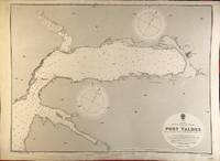
Alaska. Prince William Sound. Port Valdez. From a United States Government Chart, 1905.
by Alaska Nautical Chart
- Used
- Condition
- Used
- Quantity Available
- 1
- Seller
-
Sidney, British Columbia, Canada
- Item Price
-
SGD 241.27SGD 24.82 shipping to USA
Show Details
Description:
London: British Admiralty, 1906 (1921). . An engraved chart on heavy stock, uncolored, sheet size 27.5 x 20 inches. Published 6th June, 1906; Large Corrections 1907; Small corrections (printed) to 1921. Unfolded. Some wear and a short tear to lower margin, basically clean and very good. In lower right: "Engraved by Weller & Addison". Chart number is 3569. Small typed label on verso giving chart & folio info. Published under the Superintendence of Rear Admiral A. Mostyn Field. Valdez is an important Alaskan port, and was a key town on the Gold Rush Trail.
Item Price
SGD 241.27
SGD 24.82
shipping to USA
More Photos
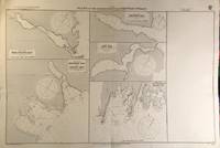
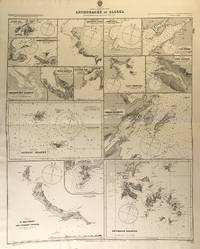
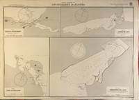
Alaska. Plans in the Neighbourhood of Chatham Strait. From the Latest United States Government Charts.
by Alaska Nautical Chart
- Used
- Condition
- Used
- Quantity Available
- 1
- Seller
-
Sidney, British Columbia, Canada
- Item Price
-
SGD 206.80SGD 24.82 shipping to USA
Show Details
Description:
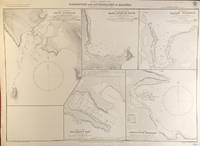
London: British Admiralty, 1907 (1921). . An engraved chart on heavy stock, uncolored, sheet size 40 x 27.5 inches. Published 2nd April 1907; Small corrections (printed) to 1921. Original vertical fold. A nice clean copy, some small additions in red pen. In lower right: "Engraved by Davies & Company.". Chart number is 3637. Small typed label on verso giving chart & folio info. Published under the Superintendence of Rear Admiral A. Mostyn Field. Plans of anchorages in Chatham Strait and Frederick Sound: Red Bluff Bay, Herring Bay and Chapin Bay, Hoggatt Bay, Gut Bay, and Surprise Harbour and Murder Cove. Murder Cove was so named for the killing of two gold prospectors in retaliation for the killing of two Tlingit tribesmen, which precipitated the fighting between the Tlingit and the US Government known as the Kake War.
Item Price
SGD 206.80
SGD 24.82
shipping to USA

More Photos
Alaska. Plans in Prince of Wales Island. From the Latest United States Government Charts.
by Alaska Nautical Chart
- Used
- Condition
- Used
- Quantity Available
- 1
- Seller
-
Sidney, British Columbia, Canada
- Item Price
-
SGD 241.27SGD 24.82 shipping to USA
Show Details
Description:
London: British Admiralty, 1907 (1925). . An engraved chart on heavy stock, uncolored, sheet size 40 x 27.5 inches. Published 23rd April 1907; New Edition 10th May 1911; Small corrections (printed) to 1925 and (mss.) to 1929. Original vertical fold. A nice clean copy, some small additions in red pen. In lower right: "Engraved by Weller & Addison". Chart number is 3634. Small typed label on verso giving chart & folio info. Published under the Superintendence of Rear Admiral A. Mostyn Field. Plans of McKenzie Inlet (Kasaan Bay), Hollis Anchorage (Kasaan Bay), Dolomi Anchorage and Port Johnson, Lyman Anchorage, and North Arm of Moira Sound. The McKenzie Inlet map shows Kasaan Village, an important historical community of the Kaigani Haida, and the most northerly Haida settlement.
Item Price
SGD 241.27
SGD 24.82
shipping to USA

More Photos
Alsatia Superior.
by Mercator (Gerard) & Jodocus Hondius
- Used
- Condition
- Used
- Quantity Available
- 1
- Seller
-
Sidney, British Columbia, Canada
- Item Price
-
SGD 103.40SGD 24.82 shipping to USA
Show Details
Description:
Amsterdam: Mercator/Hondius, 1609. . A copper engraved map on laid paper, uncoloured, from the 1609 German edition of the Mercator/Hondius ATLAS MINOR. Image size is 17.5cm x 13.5cm, on a sheet measuring 23cm x 18cm (9 x 7 inches). Cartouche at lower left. Text on map is in Latin. Text on verso is German. Page number on verso is 414. Clean, small old stain to upper right corner, very good condition. A regional map of France, Alsace, the Rhine River.
Item Price
SGD 103.40
SGD 24.82
shipping to USA

More Photos
America gezeichnet von F.v. Stulpnagel. 1843.
by Stulpnagel (F.Von) & Adolf Stieler
- Used
- Condition
- Used
- Quantity Available
- 1
- Seller
-
Sidney, British Columbia, Canada
- Item Price
-
SGD 103.40SGD 24.82 shipping to USA
Show Details
Description:
Gotha: Justus Perthes, c. 1845.. Engraved map, 12.5 x 16.5 inches. Original colour in outline. Decorative scrollwork title at the lower left. A little foxing at the bottom, original central fold, a clean very good copy. Issued in Stieler's Hand-Atlas, No. 41a.
Item Price
SGD 103.40
SGD 24.82
shipping to USA
More Photos
America - North West Coast. Anchorages in Alaska. From Plans published by the United States Government, to 1910.
by Alaska Nautical Chart
- Used
- Condition
- Used
- Quantity Available
- 1
- Seller
-
Sidney, British Columbia, Canada
- Item Price
-
SGD 137.87SGD 24.82 shipping to USA
Show Details
Description:
London: British Admiralty, 1890 (1925). . An engraved chart on heavy stock, uncolored, sheet size 27 x 33.5 inches. Published 11th Aug. 1890; New Edition July 1911; Small corrections (printed) to 1925 and (mss.) to 1929. Original horizontal fold, a nice clean copy, small additions in red pen. In lower right: "Engraved by Edwd. Weller". Chart number is 1454. Small typed label on verso giving chart & folio info. Published under the Superintendence of Captain W.J.L. Wharton. Fifteen anchorages, various sizes: Kukak Bay, Northwest and Yukon Hrs., Southwest Anche., Chernoffski Harbour, Eagle Harbour, Kulilyak Bay, Pribilof Islands, English Bay, St. Matthew and Adjacent Islands, Akun Cove, Port Etches, Port Wrangell, Port Graham, Kodiak Harbour, and Shumagin Islands.
Item Price
SGD 137.87
SGD 24.82
shipping to USA
![America N.W. Coast. Plans of Ports &c. in Queen Charlotte Islands. [Haida Gwaii]](https://d3525k1ryd2155.cloudfront.net/h/314/618/1359618314.0.m.jpg)
America N.W. Coast. Plans of Ports &c. in Queen Charlotte Islands. [Haida Gwaii]
by BC Nautical Chart
- Used
- Condition
- Used
- Quantity Available
- 1
- Seller
-
Sidney, British Columbia, Canada
- Item Price
-
SGD 137.87SGD 24.82 shipping to USA
Show Details
Description:
London: British Admiralty, 1856 (1922).. An engraved chart on heavy stock, uncolored, sheet size 20 x 27.5 inches. Originally published 1856, this is a New Edition of 1919 with printed Small corrections to 1922. No folds, a nice clean copy, some small corrections in red. At lower right: "Engraved by J. & C. Walker". Chart number is 2168. Small typed label on verso, giving chart & folio information. Small inset maps of Haida Gwaii ports & anchorages: Ikeda Cove, Athlow Bay and Port Chanal, Houston Stewart Channel and Rose Harbour, Cumshewa Inlet, Selwyn Inlet, Skincuttle Inlet, and Port Kuper.
Item Price
SGD 137.87
SGD 24.82
shipping to USA
America. North Coast. Mackenzie River to Bering Strait.
by Alaska Nautical Chart
- Used
- Condition
- Used
- Quantity Available
- 1
- Seller
-
Sidney, British Columbia, Canada
- Item Price
-
SGD 172.34SGD 24.82 shipping to USA
Show Details
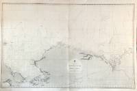
Description:
London: British Admiralty, 1856 (1932).. An engraved chart on heavy stock, uncolored, sheet size 40 x 27.5 inches. Published Febr. 20th 1856; New Edition Dec. 1908. Large Corrections to Sept. 1932. Original vertical fold, a very good copy, some light wrinkling, a few additions in red, and some route marks in pencil. In lower right: "Engraved 1856". Chart number is 2435. Small typed label on verso giving chart & folio info. A large-scale chart extending from the Chukchi Peninsula in Asia to Liverpool Bay and Cape Bathurst in the Canadian Arctic. The course of the Mackenzie River is shown, as well as the Porcupine River and Yukon River. The tip of Wrangell Island is shown at the left edge.
Item Price
SGD 172.34
SGD 24.82
shipping to USA

More Photos
America - North West Coast. Port Simpson to Cross Sound including the Koloschensk Archipelago. Chiefly from Vancouver's Survey in 1792. With corrections from a Russian Chart published in 1853.
by Alaska Nautical Chart
- Used
- Condition
- Used
- Quantity Available
- 1
- Seller
-
Sidney, British Columbia, Canada
- Item Price
-
SGD 206.80SGD 24.82 shipping to USA
Show Details
Description:
London: British Admiralty, 1865 (1927). . An engraved chart on heavy stock, uncolored, sheet size 38 x 44 inches. Published 13th July 1865; Large Corrections to July 1907; Small corrections (printed) to 1927 and (mss.) to 1930. Twice folded; original vertical and horizontal folds, a nice clean copy, many small additions in red pen, one short tear in lower margin. In lower right: "Zc 1927". Chart number is 2431. Small typed label on verso giving chart & folio info. Published under the Superintendence of Captn. G.H. Richards. A large and detailed chart extending from the Dixon Entrance north to Glacier Bay. Small inset maps of Point Highfield Anchorage and Port Tongass, and an inset continuation northward showing Skagway. Originally published 1865, this is a 1927 printing of the 1907 revised edition.
Item Price
SGD 206.80
SGD 24.82
shipping to USA

America Settentrionale divisa ne' suoi principali Stati.
by Zatta (Antonio)
- Used
- Condition
- Used
- Quantity Available
- 1
- Seller
-
Sidney, British Columbia, Canada
- Item Price
-
SGD 1,034.02SGD 24.82 shipping to USA
Show Details
Description:
Venice, [1779-1785]. . Engraved map. Image size is 16 x 12 inches on a sheet measuring 22 x 16 inches. Coloured cartouche in lower left, the map has colouring in outline. Small tape repair to verso at top of fold, in margin, nice condition overall. Issued as part of Zatta's 4 volume work: Atlante Novissimo, published 1779 - 1785. A very attractive map, with a handsome cartouche.
Item Price
SGD 1,034.02
SGD 24.82
shipping to USA
More Photos
America. North West Coast. Anchorages in Alaska. From the latest United States Government Charts.
by Alaska Nautical Chart
- Used
- Condition
- Used
- Quantity Available
- 1
- Seller
-
Sidney, British Columbia, Canada
- Item Price
-
SGD 137.87SGD 24.82 shipping to USA
Show Details
Description:
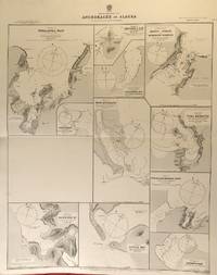
London: British Admiralty, 1900 (1924). . An engraved chart on heavy stock, uncolored, sheet size 27.5 x 20 inches. Published 29th May, 1900; Large Corrections April 1905. Small corrections (printed) to 1924. Unfolded, a nice clean copy. In lower right: "Engraved by Davies & Company". Chart number is 3136. Small typed label on verso giving chart & folio info. Published under the Superintendence of Rear Admiral Sir W.J.L. Wharton. Maps of four anchorages on Kodiak Island: Karluk Anchorage, Larsens Bay, Uyak Anchorage, Shearwater Bay.
Item Price
SGD 137.87
SGD 24.82
shipping to USA

More Photos
America. North Coast. Mackenzie River to Bering Strait.
by Alaska Nautical Chart
- Used
- Condition
- Used
- Quantity Available
- 1
- Seller
-
Sidney, British Columbia, Canada
- Item Price
-
SGD 172.34SGD 24.82 shipping to USA
Show Details
Description:
London: British Admiralty, 1856 (1928).. An engraved chart on heavy stock, uncolored, sheet size 40 x 27.5 inches. Published Febr. 20th 1856; New Edition Dec. 1908. Large Corrections to 25th May 1928. Original vertical fold, a nice clean copy, some dust soiling to margins on verso. In lower right: "Engraved 1856" and "Zzc 1928". Chart number is 2435. Small typed label on verso giving chart & folio info. A large-scale chart extending from the Chukchi Peninsula in Asia to Liverpool Bay and Cape Bathurst in the Canadian Arctic. The course of the Mackenzie River is shown, as well as the Porcupine River and Yukon River. The tip of Wrangell Island is shown at the left edge.
Item Price
SGD 172.34
SGD 24.82
shipping to USA
More Photos
America - North West Coast. Alaska. Anchorages In and Near Sumner Strait. From Plans Published by the U.S. Government, 1888.
by Alaska Nautical Chart
- Used
- Condition
- Used
- Quantity Available
- 1
- Seller
-
Sidney, British Columbia, Canada
- Item Price
-
SGD 137.87SGD 24.82 shipping to USA
Show Details
Description:
London: British Admiralty, 1890 (1924). . An engraved chart on heavy stock, uncolored, sheet size 33.5 x 27 inches. Published 11th Aug. 1890; Large Corrections to Aug. 1898; Small corrections (printed) to 1924 and (mss.) to 1927. Original vertical fold, a nice clean copy, small additions in red pen. In lower right: "Engraved by Edwd. Weller". Chart number is 1449. Small typed label on verso giving chart & folio info. Published under the Superintendence of Captain W.J.L. Wharton. Two large charts of anchorages: Port McArthur and Red Bay; the Port McArthur plan includes a small inset map of Port Conclusion.
Item Price
SGD 137.87
SGD 24.82
shipping to USA
More Photos
America - North West Coast. Harbours and Anchorages in Alaska. From United States Government Surveys 1901.
by Alaska Nautical Chart
- Used
- Condition
- Used
- Quantity Available
- 1
- Seller
-
Sidney, British Columbia, Canada
- Item Price
-
SGD 137.87SGD 24.82 shipping to USA
Show Details
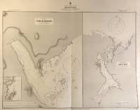
Description:
London: British Admiralty, 1904 (1928). . An engraved chart on heavy stock, uncolored, sheet size 27.5 x 20 inches. Published 11th Nov. 1904; Small corrections (printed) to 1928. Unfolded, a nice clean copy. In lower right: "Engraved 1904" and "Zc 1928". Chart number is 3464. Small typed label on verso giving chart & folio info. Published under the Superintendence of Captain A. Mostyn Field. Maps of five anchorages in the Ikatan Peninsula and Sanak Island: Dora Harbour, East Anchor Cove, Sanak (Acherk) Harbour, Peterson Bay, and North East Harbour.
Item Price
SGD 137.87
SGD 24.82
shipping to USA
More Photos
America - North West Coast. Alaska. Anchorages In Sumner and Clarence Straits. From plans published by the U.S. Government, 1888.
by Alaska Nautical Chart
- Used
- Condition
- Used
- Quantity Available
- 1
- Seller
-
Sidney, British Columbia, Canada
- Item Price
-
SGD 172.34SGD 24.82 shipping to USA
Show Details
Description:
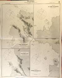
London: British Admiralty, 1890 (1925). . An engraved chart on heavy stock, uncolored, sheet size 27 x 34 inches. Published 2nd Aug. 1890; Small corrections (printed) to 1925 and (mss.) to 1927. Original horizontal fold, a nice clean copy, small additions in red pen. In lower right: "Engraved by Edwd. Weller". Chart number is 1433. Small typed label on verso giving chart & folio info. Published under the Superintendence of Captain W.J.L. Wharton. Four charts: Port Protection, Steamer Bay, St. John Harbour, and Dewey Anchorage. Currently, residents of Port Protection are featured in the National Geographic Channel reality series: Life Below Zero: Port Protection, and its spinoff: Lawless Island.
Item Price
SGD 172.34
SGD 24.82
shipping to USA

More Photos
America Meridionalis.
by Mercator (Gerard) & Jodocus Hondius & Johannes Jansson
- Used
- Condition
- Used
- Quantity Available
- 1
- Seller
-
Sidney, British Columbia, Canada
- Item Price
-
SGD 137.87SGD 24.82 shipping to USA
Show Details
Description:
Amsterdam: Jansson, Mercator/Hondius, 1628. . A copper engraved map on laid paper, uncoloured, from the 1628 Latin edition of the Mercator/Hondius ATLAS MINOR. Image size is 19cm x 14.5cm, on a sheet measuring 23.5cm x 17cm (9 x 6.5 inches). Cartouche and compass rose at lower right. Text on map is in Latin. Text on verso is Latin. Page number on verso is 652. Clean, very good condition. A detailed map of South America.
Item Price
SGD 137.87
SGD 24.82
shipping to USA
More Photos
America - North West Coast. Anchorages in Alaska. From Plans published by the United States Government.
by Alaska Nautical Chart
- Used
- Condition
- Used
- Quantity Available
- 1
- Seller
-
Sidney, British Columbia, Canada
- Item Price
-
SGD 137.87SGD 24.82 shipping to USA
Show Details
Description:
London: British Admiralty, 1890 (1924). . An engraved chart on heavy stock, uncolored, sheet size 27 x 33.5 inches. Published 2nd Aug. 1890; Large Corrections to Nov. 1908; Small corrections (printed) to 1924 and (mss.) to 1929. Original horizontal fold, a nice clean copy, small additions in red pen. In lower right: "Engraved by Edwd. Weller". Chart number is 1457. Small typed label on verso giving chart & folio info. Published under the Superintendence of Captain W.J.L. Wharton. Eleven anchorages: Unalaska Bay (Captains Bay), Cape Etolin, Simeonof I. & Hr., Samganuda Bay, Popof Strait and Humboldt Harbour, Port Mulgrave, Coal Harbour, Doris & Anchorage Bays, Nateekin Bay, Liituya Bay, and Sanborn Hr.
Item Price
SGD 137.87
SGD 24.82
shipping to USA

Didn’t find what you’re looking for?
Try adding this search to your want list. Millions of books are added to our site everyday and when we find one that matches your search, we’ll send you an email. Best of all, it’s free.
Add to Want List

Are you a frequent reader or book collector?
Join the Bibliophile's Club and save 10% on every purchase, every day — up to $20 savings per order!

Social Responsibility
Did you know that since 2004, Biblio has used its profits to build 16 public libraries in rural villages of South America?
