Description:
Suffolk:, 1816.. Margins chipped with losses else very good. . 7-1/4" x 8"-18.4 x 20.3 cm.. A detailed map of the African continent. Gold mines, mountains, rivers and towns are depicted.
Search Results: Authors starting with B from Webster's Fine Books & Maps, ABAC, ILAB
You searched for:
- Bookseller inventory: Webster's Fine Books & Maps, ABAC, ILAB (authors starting with B)
- Bookseller: Webster's Fine Books & Maps, ABAC, ILAB
Results 1 - 20 of 74

AFRICA FROM THE LATEST AUTHORITIES
by Barlow, John
- Used
- Condition
- Used - Margins chipped with losses else very good.
- Quantity Available
- 1
- Seller
-
Port Hope, Ontario, Canada
- Item Price
-
SGD 130.24SGD 19.19 shipping to USA
Show Details
Item Price
SGD 130.24
SGD 19.19
shipping to USA
A Chart Of Magnetic Curves Of Equal Variation
by Barlow, Peter/Aikman, G.
- Used
- Condition
- Used - A couple of light spots to the South Pacific and upper left corner with tears with small losses, else very good.
- Quantity Available
- 1
- Seller
-
Port Hope, Ontario, Canada
- Item Price
-
SGD 130.24SGD 19.19 shipping to USA
Show Details
Description:
An interesting chart showing the magnetic curves throughout the world's ocean's and seas. Barlow trained in mathematics and spent ten years studying the field of magnetism as well as experimenting with optics. In 1825 he was awarded the Copley medal from the Royal Society for his work in magnetism.
Item Price
SGD 130.24
SGD 19.19
shipping to USA
W.H.SMITH & SON'S REDUCED ORDNANCE MAP OF GLOUCESTER, CHELTENHAM AND ENVIRONS
by Bartholomew, John
- Used
- Hardcover
- Condition
- Used
- Binding
- Hardcover
- Quantity Available
- 1
- Seller
-
Port Hope, Ontario, Canada
- Item Price
-
SGD 54.84SGD 19.19 shipping to USA
Show Details
Description:
London: : W.H. Smith & Son,, n.d. 13-1/4" x 18-1/4"- 33.6 x 46.3 cm. Colour lithograph map backed on linen and housed in red folding cloth covers with original paper label. label and boards scuffed, small closed tears to lower blank margin, else a very good copy. A detailed map of Hereford and Gloucester showing towns, villages, green areas and Railway lines.
Item Price
SGD 54.84
SGD 19.19
shipping to USA
W.H.SMITH & SON'S REDUCED ORDNANCE MAP OF OXFORD AND ENVIRONS
by Bartholomew, John
- Used
- Hardcover
- Condition
- Used
- Binding
- Hardcover
- Quantity Available
- 1
- Seller
-
Port Hope, Ontario, Canada
- Item Price
-
SGD 89.11SGD 19.19 shipping to USA
Show Details
Description:
London: : W.H. Smith & Son,, n.d. 13-1/4" x 18-1/4"- 33.6 x 46.3 cm. Colour lithograph map backed on linen and housed in folding cloth covers with original paper label. Upper cover detached, else a very good copy. A detailed map of Oxford showing towns, villages, green areas and Railway lines.
Item Price
SGD 89.11
SGD 19.19
shipping to USA
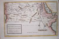
LIBYA INTERIOR, GARAMANTUM ET MELANOGAETVLORVM REGIO, AETHIOPIA SVB AEGYPTO, AETHIOPIA INTERIOR &C.
by Basire, Isaac
- Used
- Condition
- Used - Very good dark impression
- Quantity Available
- 1
- Seller
-
Port Hope, Ontario, Canada
- Item Price
-
SGD 116.53SGD 19.19 shipping to USA
Show Details
Description:
A very good map of Libya, Egypt, Ethiopia and the Arabian Sea. Towns, ports, seas and the Nile River are shown.
Item Price
SGD 116.53
SGD 19.19
shipping to USA
MAVRETANIA, NVMIDIA, GAETVLIA &C.
by Basire, Isaac
- Used
- Condition
- Used - Very good dark impression
- Quantity Available
- 1
- Seller
-
Port Hope, Ontario, Canada
- Item Price
-
SGD 89.11SGD 19.19 shipping to USA
Show Details
Description:
A very good map of northwestern Africa, including Mauretania, Numidia, and southern Algeria . Shows towns, ports and the Atlas mountains.
Item Price
SGD 89.11
SGD 19.19
shipping to USA
RUSSIA SETTENRIONALE OVVERO MOSCOVIA EUROPEA
by Batelli
- Used
- Condition
- Used
- Quantity Available
- 1
- Seller
-
Port Hope, Ontario, Canada
- Item Price
-
SGD 130.24SGD 19.19 shipping to USA
Show Details
Description:
From "Nuovo Atlante DI Geografia Universale..." published in Milan by Batelli & Fanfani [c. 1821] . 7" x 8-1/4"-17.7 x 20.9 cm. Hand-coloured in outline margins a little ragged but nice and wide, a very good impression. A detailed map showing Finland, Lapland and northern Russia.
Item Price
SGD 130.24
SGD 19.19
shipping to USA
FRANCIA COMPARATIVA IN PROVINCIE E IN DIPARIMENTI
by [Batelli]
- Used
- Condition
- Used
- Quantity Available
- 1
- Seller
-
Port Hope, Ontario, Canada
- Item Price
-
SGD 212.49SGD 19.19 shipping to USA
Show Details
Description:
From "Nuovo Atlante DI Geografia Universale..." published in Milan by Batelli & Fanfani [c. 1821] . 13-1/2" x 16"- 34.2 x 40 cm. Hand-coloured in outline nice wide margins, some spotting to margins, but generally a very good impression. A detailed double page map of France divided into departments.
Item Price
SGD 212.49
SGD 19.19
shipping to USA
PERSIA
by [Batelli]
- Used
- Condition
- Used
- Quantity Available
- 1
- Seller
-
Port Hope, Ontario, Canada
- Item Price
-
SGD 171.36SGD 19.19 shipping to USA
Show Details
Description:
From "Nuovo Atlante DI Geografia Universale..." published in Milan by Batelli & Fanfani [c. 1821] . 7" x 8-1/4"-17.7 x 20.9 cm. Hand-coloured in outline nice wide margins, a very good impression. A detailed map of the Middle East including Armenia, Khorasan, Candahar, Kerman, Khohistan, Segistan the Caspian Sea and the Perisan Gulf.
Item Price
SGD 171.36
SGD 19.19
shipping to USA
History of British Columbia From its Earliest Discovery to the Present Time
by Begg, Alexander
- Used
- Hardcover
- Condition
- Used - Spine sunned, spine ends worn, 2” tear to map at left margin otherwise very good.
- Binding
- Hardcover
- Quantity Available
- 1
- Seller
-
Port Hope, Ontario, Canada
- Item Price
-
SGD 185.07SGD 19.19 shipping to USA
Show Details
Description:
1894.. Spine sunned, spine ends worn, 2” tear to map at left margin otherwise very good.. 4to, . Toronto: William Briggs, original blue and gilt stamped cloth. Lande 945; Lowther 1097. A comprehensive history of the western Canadian province from the early navigators of Captain Cook, Sir Francis Drake, Captain John Meares and Captain George Vancouver to the 1892 Alaskan boundary report. Canada, British Columbia, West coast, Pacific Northwest, Alaska
Item Price
SGD 185.07
SGD 19.19
shipping to USA
AMERIQUE MERIDIONALE
by Bellin, Jacques Nicolas
- Used
- Condition
- Used
- Quantity Available
- 1
- Seller
-
Port Hope, Ontario, Canada
- Item Price
-
SGD 164.51SGD 19.19 shipping to USA
Show Details
Description:
From "Histoire Generale des Voyages": Paris, , 1757. 7-3/4" x 16"- 19.6 x 15.2 cm. Copper engraved map. Small closed tear right margin, else very good. A small map of South America including mountain ranges, towns, ports and the Amazon River.
Item Price
SGD 164.51
SGD 19.19
shipping to USA
COSTE OCCIDENTALE D'AFRIQUE DEPUIS LE XIE DEGRE DE LATITUDE MERIDIONALE JUSQU'AU CAP DE BONNE ESPERANCE. TIREE DE LA CARTE FRANCOISE DE L'OCEAN MERIDIONAL
by Bellin, Jacques Nicolas
- Used
- Condition
- Used
- Quantity Available
- 1
- Seller
-
Port Hope, Ontario, Canada
- Item Price
-
SGD 205.64SGD 19.19 shipping to USA
Show Details
Description:
From "Histoire Generale des Voyages": Paris, , 1749. 9-1/2" x 10-1/4"- 24.1 x x 26 cm. Copper engraved map hand coloured in outline. A couple of brown spots lower neatline, else very good. A good map from the Benguela coast of west Africa to the Cape of Good Hope.
Item Price
SGD 205.64
SGD 19.19
shipping to USA
CARTE DE LA COSTE ORIENTALE D'AFRIQUE DEPUIS LE XIIE DEGRE DE LATITUDE MERIDIONALE JUSQ'AU XVIE DEGRE DE LATITUDE SEPTENTRIONALE
by Bellin, Jacques Nicolas
- Used
- Condition
- Used
- Quantity Available
- 1
- Seller
-
Port Hope, Ontario, Canada
- Item Price
-
SGD 164.51SGD 19.19 shipping to USA
Show Details
Description:
From "Histoire Generale des Voyages": Paris, , 1749. 9-1/2" x 7-1/2"- 24.1 x 19 cm. Copper engraved map hand coloured in outline. Small closed tear left margin, some offsetting yet still generally very good. A detailed coastal map of the east coast of Africa after the Count of Maurepas' map in 1740.
Item Price
SGD 164.51
SGD 19.19
shipping to USA
CARTE DE LA COSTE ORIENTALE D'AFRIQUE DEPUIS LE CAP DE BONNE ESPERANCE JUSQU'AU CAP DEL GADA TIREE DE LA CARTE FRANCOISE DE L'OCEAN ORIENTAL
by Bellin, Jacques Nicolas
- Used
- Condition
- Used
- Quantity Available
- 1
- Seller
-
Port Hope, Ontario, Canada
- Item Price
-
SGD 205.64SGD 19.19 shipping to USA
Show Details
Description:
From "Histoire Generale des Voyages": Paris, , 1749. 9-1/2" x 8-3/4"- 24.1 x 22.2 cm. Copper engraved map hand coloured in outline. Left margin trimmed close as issued, else very good. A detailed map of the eastern coast of Africa from the Zanzibar coast to the Cape of Good Hope.
Item Price
SGD 205.64
SGD 19.19
shipping to USA
CARTE EXACTE DE LA COTE DU CAP VERD
by Bellin, Jacques Nicolas
- Used
- Condition
- Used
- Quantity Available
- 1
- Seller
-
Port Hope, Ontario, Canada
- Item Price
-
SGD 109.67SGD 19.19 shipping to USA
Show Details
Description:
From "Histoire Generale des Voyages": Paris, , 1749. 8-1/4" x 5-1/2"- 20.9 x 13.9 cm. Copper engraved map hand coloured in outline. Left margin trimmed close as issued, else very good. A map of the coast of Cape Verd showing where Barbot sailed and showing below views of Cape Emanuel and the Island of Goree.
Item Price
SGD 109.67
SGD 19.19
shipping to USA
CARTE DE TOUTES LES ISLES CONNUES A LA COSTE DE ZANGUEBAR ET MADAGASCAR QUE L'ON TROUVE DANS LA ROUTE DE L'INDE
by Bellin, Jacques Nicolas
- Used
- Condition
- Used
- Quantity Available
- 1
- Seller
-
Port Hope, Ontario, Canada
- Item Price
-
SGD 233.05SGD 19.19 shipping to USA
Show Details
Description:
From "Histoire Generale des Voyages": Paris, , 1749. 9" x 10-3/4"- 22.8 x 27.3 cm. Copper engraved map hand coloured in outline. Small closed tear left margin, toned overall generally very good. A detailed coastal map of the east coast of Africa including the island of Madagascar and the islands in the Indian Ocean.
Item Price
SGD 233.05
SGD 19.19
shipping to USA
PLAN DE LA RADE ET VILLE DE LA VERA-CRUZ SITUEE PAR 19 DE. 10 MIN. DE LAT. SEP. ET 100 D. 15 M. A L'OCCID. DE PARIS
by Bellin, Jacques Nicolas
- Used
- Condition
- Used
- Quantity Available
- 1
- Seller
-
Port Hope, Ontario, Canada
- Item Price
-
SGD 164.51SGD 19.19 shipping to USA
Show Details
Description:
From "Histoire Generale des Voyages": Paris, , 1754. 8-1/4" x 6"- 20.9 x 15.2 cm. Copper engraved map hand coloured in outline. Offsetting, crease to lower left corner, otherwise very good. A plan of Vera-Cruz with legend showing the main church, the Governor's house, several roads,and Jesuit quarters. etc. According to legend the Island off of Vera Cruz "Isle de Sacrifices" was so named because it was where the Spaniards first witnessed human sacrifices.
Item Price
SGD 164.51
SGD 19.19
shipping to USA
KARTE DES MEERBUSENS ST.LAURENZ UND DER BENACHBARTEN LAENDER ZUR ALLGEMEINEN HISTORIE DER REISEN. 1744
by Bellin, Jacques Nicolas/Schwabe, Johan
- Used
- Condition
- Used
- Quantity Available
- 1
- Seller
-
Port Hope, Ontario, Canada
- Item Price
-
SGD 205.64SGD 19.19 shipping to USA
Show Details
Description:
From "Allgemeine Historie der Reisen zu Wasser und zu Lande" Leipzig, , 1758. 8-1/2" x 14"- 21.5 x 35.5 cm. Copper engraved map with hand colouring. Upper and lower margins trimmed to neatline, crude colouring. A good map of the Gulf of St. Lawrence with the Islands of Anticosti, Isle St. Jean, Isle Royale and Newfoundland.
Item Price
SGD 205.64
SGD 19.19
shipping to USA
CARTE DE LA PETIT BUKHARIE ET PAYS VOISINS
by Bellin, Jacques Nicolas.
- Used
- Condition
- Used - Folds as issued, else very good.
- Quantity Available
- 1
- Seller
-
Port Hope, Ontario, Canada
- Item Price
-
SGD 137.09SGD 19.19 shipping to USA
Show Details
Description:
A good map of the Central Asia including southeastern Kazakhstan, most of Kyrgyzstan, northwestern China, and southwestern Mongolia.
Item Price
SGD 137.09
SGD 19.19
shipping to USA
PLAN DU PORT ET DE LA VILLE DE NANGASKI
by Bellin, Jacques Nicolas
- Used
- Condition
- Used
- Quantity Available
- 1
- Seller
-
Port Hope, Ontario, Canada
- Item Price
-
SGD 377.00SGD 19.19 shipping to USA
Show Details
Description:
From "Histoire Generale des Voyages": Paris, , 1752. 7-1/2" x 13"- 19 x 33 cm. Copper engraved map hand coloured in outline. Offsetting, small closed tear extending just into neatline below cartouche, else very good. A detailed plan of the city of Nangaski (Nagasaki) including the Emperor's Palace, Governor's houses, temples, the house of the Port inspector and the Chinese quarter. The port indicates an area where Dutch ships were docked.
Item Price
SGD 377.00
SGD 19.19
shipping to USA

Didn’t find what you’re looking for?
Try adding this search to your want list. Millions of books are added to our site everyday and when we find one that matches your search, we’ll send you an email. Best of all, it’s free.
Add to Want List

Are you a frequent reader or book collector?
Join the Bibliophile's Club and save 10% on every purchase, every day — up to $20 savings per order!

Social Responsibility
Did you know that since 2004, Biblio has used its profits to build 16 public libraries in rural villages of South America?
