Description:
Devonport: Hiorns and Miller,, 1928. First edition, first impression, scarce, with just two locations on Library Hub (British Library and National Maritime Museum), WorldCat adding one only, at Plymouth Library. It was published "to commemorate the first commission of HMS Emerald". The first part is "a short account of the voyaging and deeds" of the ship, which went to China, India, East Africa and the Persian Gulf between 1926 and 1928. There are some curious stories related in this section, including a meeting with Ibn Saud in which the crew of the Emerald give the king a gift of his favourite beverage - home-made soda water - and a long account of preparations for the defence of Kuwait, a description of the town and some comments on Sheikh Ahmed al-Jaber al-Sabah, Emir of Kuwait. The second part is a collection of writings by other members of the crew, including many anecdotes and humorous poems by Captain H. G. C. Franklin. The third and final part is a summary of the sports and entertainment…
Read More Search Results: Titles starting with H from Peter Harrington
You searched for:
- Bookseller inventory: Peter Harrington (titles starting with H)
- Bookseller: Peter Harrington
Results 1 - 20 of 488

More Photos
H.M.S. Emerald.
by SURTEES, Villiers Nicholas.
- Used
- Hardcover
- first
- Condition
- Used
- Binding
- Hardcover
- Quantity Available
- 1
- Seller
-
London, United Kingdom
- Item Price
-
SGD 1,117.35SGD 20.63 shipping to USA
Show Details
Item Price
SGD 1,117.35
SGD 20.63
shipping to USA
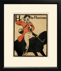
H for Huntsman
by NICHOLSON, William.
- Used
- Condition
- Used
- Quantity Available
- 1
- Seller
-
London, United Kingdom
- Item Price
-
SGD 378.18SGD 20.63 shipping to USA
Show Details
Description:
An Alphabet. Heinemann., 1898.. Lithograph after original woodcut by William Nicholson from his famous Alphabet book. Nicholson (1872 - 1949) was a printmaker years before he became known as a portrait and landscape painter. He produced posters for commercial products and theatrical events. The style of these posters - simple shapes and flat colour - became the hallmarks of Nicholson's graphic work. The Alphabet, published in 1898 firmly established him in the public's mind and brought him immediate success. Chromolithograph. Printed colour. Fine condition. Framed size: 35.5 x 41 cm Size: 19.5 x 24.5 cm. (7½ x 9½ inches). Presented in a black frame with conservation mount.
Item Price
SGD 378.18
SGD 20.63
shipping to USA
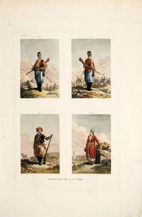
HABITANS DE LA CARIE.
by CHOISEUL-GOUFFIER, Marie Gabriel F. A., Comte de.
- Used
- Condition
- Used
- Quantity Available
- 1
- Seller
-
London, United Kingdom
- Item Price
-
SGD 257.85SGD 20.63 shipping to USA
Show Details
Description:
Paris., 1782. Four engravings on one plate showing citizens of 'Carie' on the Turkish mainland. This plate is from Volume I of Choiseul-Gouffier's Voyage Pittoresque, a cartographic survey of the Mediterranean and an account of his tour (with the artist, J.B. Hilaire) of Greece, the Greek islands, and the coast of Asia Minor. According to Brunet, it was incontestably the most beautiful production of its kind seen until then. Choiseul-Gouffier's work offered for the first time, illustrations of remote places that complemented the scrupulously researched narrative. Copper engraving. Later colour. Fine condition. Size: 20.5 x 31 cm.
Item Price
SGD 257.85
SGD 20.63
shipping to USA
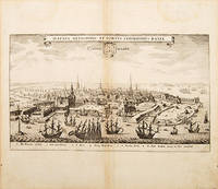
HAFNIA METROPOLIS ET PORTUS CELEBERRIMUS DANIAE.: COPPENHAGEN
by GOTTFRIED, Johann Ludwig. Engraved by MERIAN, Matthew.
- Used
- Condition
- Used
- Quantity Available
- 1
- Seller
-
London, United Kingdom
- Item Price
-
SGD 550.08SGD 20.63 shipping to USA
Show Details
Description:
Archontologia Cosmica., 1649.. Appealing view of Copenhagen from Merian's Neuwe Archontologica Cosmica. Copper engraving. Hand coloured. Very good condition; light browning and stains to margins; browning to the centrefold. Size: 34 x 20 cm.
Item Price
SGD 550.08
SGD 20.63
shipping to USA
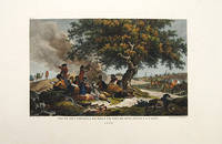
HALTE DES VOYAGEURS PRÈS DE DOURLACH, DANS LA CARIE.: Pl. 74.
by CHOISEUL-GOUFFIER, Marie Gabriel F. A., Comte de.
- Used
- Condition
- Used
- Quantity Available
- 1
- Seller
-
London, United Kingdom
- Item Price
-
SGD 257.85SGD 20.63 shipping to USA
Show Details
Description:
Paris., 1782. A very pretty view in which a group of travellers relax in the shade of a tree, some smoking hookahs. Their weapons are laid on the ground in front of them, and their horses graze behind them. In the background is the town they are heading towards. In 1776 Choiseul-Gouffier and the artist J.B. Hilaire joined a cartographic survey of the Mediterranean. Volume I of Voyage Pittoresque, his account of their tour of the Greek islands, the coast of Asia Minor, and of his travels on the mainland, was immediately acclaimed on publication in 1778. According to Brunet, it was incontestably the most beautiful production of this kind seen until then. Choiseul-Gouffier's work offered for the first time, illustrations of remote places that complemented the scrupulously researched narrative. Copper engraving. Later colour. Fine condition, with wide margins. Size: 37 x 25.5 cm. (14½ x 10 inches)
Item Price
SGD 257.85
SGD 20.63
shipping to USA
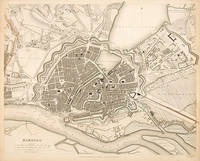
HAMBURG.
by Engraved by DAVIES, B.R.
- Used
- Condition
- Used
- Quantity Available
- 1
- Seller
-
London, United Kingdom
- Item Price
-
SGD 335.21SGD 20.63 shipping to USA
Show Details
Description:
London: Society for the Diffusion of Useful Knowledge,, 1844. Crisp and detailed map of Hamburg showing harbour, streets, fortifications and major buildings. Title and scales at lower left. Steel engraving. Original outline colour. Good condition. Size: 41 x 34 cm. (16 x 13½ inches)
Item Price
SGD 335.21
SGD 20.63
shipping to USA
HANTONIAE comitatus cum BERCHERIA.: Hampshire and Berkshire.
by JANSSON, Jan.
- Used
- Condition
- Used
- Quantity Available
- 1
- Seller
-
London, United Kingdom
- Item Price
-
SGD 1,203.30SGD 20.63 shipping to USA
Show Details
Description:
Atlas Novus., 1647, German.. Attractive map of Hampshire and Berkshire. North to the right of map. Compass at sea. Nine coats of arms, flanked by cherubs, decorated cartouche at lower left, secondary cartouche at top right 'In 1647, a fourth volume was published, with maps of British Isles transferred from Volume 1'. Ref: Koeman, Atlantes Neerlandica, p377. Koeman 5220:1 Copper engraving. Original colour. Fine condition. Size: 55 x 44 cm. (21½ x 17½ inches). Koeman, Atlantes Neerlandicae I, 5220:1
Item Price
SGD 1,203.30
SGD 20.63
shipping to USA
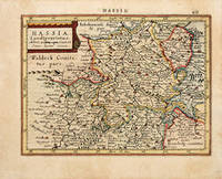
HASSIA Landtgravatus.: Tuscany
by HONDIUS, Jodocus, &, Jan Jansson.
- Used
- Condition
- Used
- Quantity Available
- 1
- Seller
-
London, United Kingdom
- Item Price
-
SGD 189.09SGD 20.63 shipping to USA
Show Details
Description:
Atlas Minor. Jan Jansson the Elder., 1628, Latin edition.. ATLAS MINOR In 1604 Hondius bought the plates of Gerard Mercator's atlas, added about 40 maps to Mercator's original number, and from 1606 published enlarged editions in many languages still under Mercator's name, but with his own name as publisher. These atlases have become known as the Mercator/Hondius series. The following year the maps were re-engraved in miniature form and issued as a pocket Atlas Minor. Copper engraving. Later colour. In fine condition. Size: 19 x 12 cm. (7½ x 4½ inches) Bannister/Moreland - Antique Maps pp. 97 & 102.
Item Price
SGD 189.09
SGD 20.63
shipping to USA
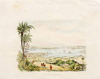
HAVANA.
by EDOUARD, Charton. M.
- Used
- Condition
- Used
- Quantity Available
- 1
- Seller
-
London, United Kingdom
- Item Price
-
SGD 77.36SGD 20.63 shipping to USA
Show Details
Description:
1879. Size: 12 x 9 cm. (4½ x 3½ inches) Wood engraving. Hand coloured. Very good condition; some browning to the top margin, not affecting the image.
Item Price
SGD 77.36
SGD 20.63
shipping to USA
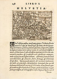
HELVETIA.
by BOTERO, Giovanni.
- Used
- Condition
- Used
- Quantity Available
- 1
- Seller
-
London, United Kingdom
- Item Price
-
SGD 146.12SGD 20.63 shipping to USA
Show Details
Description:
RELATIONI UNIVERSALI DI GIOVANNI BOTERO BENESE., 1598. Giovanni Botero (1533-1617) was Secretary to the Duke of Savoy when he compiled his Relationi Universali; "this political and geographical description of the different countries of the world was very successful and translated into a number of languages" (Burden), including English (London 1603).. HELVETIAE DESCRIPTIO AEGIDIO TSCHVDO AUTORE Copper engraving. Uncoloured. Fine condition. Size: 110 x 80 mm. (4½ x 3 inches)
Item Price
SGD 146.12
SGD 20.63
shipping to USA
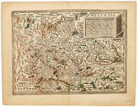
HELVETIA.
by QUAD, Matthias.
- Used
- Condition
- Used
- Quantity Available
- 1
- Seller
-
London, United Kingdom
- Item Price
-
SGD 593.06SGD 20.63 shipping to USA
Show Details
Description:
Fascilus Geographicus., 1608. Handsome map of Switzerland, with north at lower edge of map. The map is based on the 1538 map of the Swiss cartographer Aegidicus Tschudi., also used by Ortelius, before Quad included it in his work. Matthaus Quad was a German cartographer based in Cologne, which, at the time was the centre for German cartography. This map is from his Fascilus Geographicus. It was printed by Johannes Bussemacher. Copper engraving. Some early colouring. Very good condition. Some place-names, rivers and forests are highlighted in brown and green. Size: 260 x 180 mm. (10 x 7 inches).
Item Price
SGD 593.06
SGD 20.63
shipping to USA
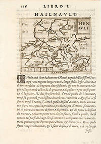
HENAULT: Hannonia.
by BOTERO, Giovanni.
- Used
- Condition
- Used
- Quantity Available
- 1
- Seller
-
London, United Kingdom
- Item Price
-
SGD 103.14SGD 20.63 shipping to USA
Show Details
Description:
RELATIONI UNIVERSALI DI GIOVANNI BOTERO BENESE., 1598. Giovanni Botero (1533-1617) was Secretary to the Duke of Savoy when he compiled his Relationi Universali; "this political and geographical description of the different countries of the world was very successful and translated into a number of languages" (Burden), including English (London 1603). Copper engraving. Uncoloured. Fine condition. map on sheet 20 x 15 cm. Map in Latin; accompanying text in Italian. Size: 11 x 8 cm. (4½ x 3 inches)
Item Price
SGD 103.14
SGD 20.63
shipping to USA
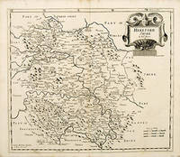
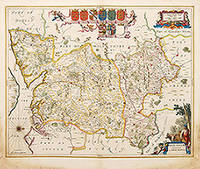
HEREFORDSHIRE.
by MORDEN, Robert
- Used
- first
- Condition
- Used
- Quantity Available
- 1
- Seller
-
London, United Kingdom
- Item Price
-
SGD 189.09SGD 20.63 shipping to USA
Show Details
Description:
Gibson's Britannia, first Morden edition. Abel Swale & John Churchill., 1695.. Beautiful map of Herefordshire. Cartouche at top right, scale lower right. The 1695 edition of Camden's Britannia was the first edition to contain Robert Morden's beautiful county maps. Morden went to considerable trouble to make them as accurate as possible, and they were the first county maps to include roads. Copper engraving. Uncoloured. Very good condition. Size: 42 x 36 cm. (16½ x 14 inches)
Item Price
SGD 189.09
SGD 20.63
shipping to USA
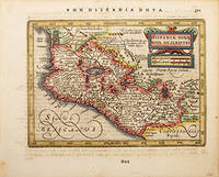
HISPANIAE NOVAE NOVA DESCRIPTIO
by JANSSON, Jan
- Used
- Condition
- Used
- Quantity Available
- 1
- Seller
-
London, United Kingdom
- Item Price
-
SGD 335.21SGD 20.63 shipping to USA
Show Details
Description:
Atlas Minor., c.1648, German edition.. Johannes Janssonius (1588 - 1664), more familiarly known as Jan Jansson, was a Dutch cartographer who produced his first maps of France and Italy in 1616 and continued from then onwards publishing a large number of maps which were almost comparable to Blaeu in quality. During the 1630s he went into partnership with his brother-in-law Henricus Hondius and published more editions of the highly regarded Mercator/Hondius/Jansson atlases. Copper engraving. Hand coloured. Fine condition. Size: 19 x 13 cm. (7½ x 5 inches)
Item Price
SGD 335.21
SGD 20.63
shipping to USA
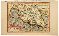
HISTRIA.
by BERTIUS, Petrus.
- Used
- Condition
- Used
- Quantity Available
- 1
- Seller
-
London, United Kingdom
- Item Price
-
SGD 378.18SGD 20.63 shipping to USA
Show Details
Description:
Bertii Tabularum geographicarum. Amsterdam: Jodocus Hondius., 1616. Very attractive little map of the northern Adriatic near Trieste. Ships and monsters at sea. Petrus Bertius was a professor of mathematics and librarian at Leyden University. As well as being a prolific writer on mathematical, historical and theological subjects he is known as a cartographer for his editions of Ptolemy's Geographia. In 1618 he moved to Paris and became Official Cosmographer to Louis XIII. He was related by marriage to Jodocus Hondius and Pieter van den Keere. Copper engraving. Later colour. Top edge cropped, shaving tops of some letters. Very good condition. Size: 13 x 9.5 cm. (5 x 3½ inches)
Item Price
SGD 378.18
SGD 20.63
shipping to USA
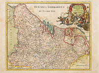
HODIERNAE BELGICAE five GERMANIA INFERIORIS Tabula
by CLUVER, Philipp
- Used
- Condition
- Used
- Quantity Available
- 1
- Seller
-
London, United Kingdom
- Item Price
-
SGD 300.82SGD 20.63 shipping to USA
Show Details
Description:
Atlas Geographus., 1711-17. A detailed and colourful map of what is now Belgium and part of north west Germany with Cluver's idiosyncratic elaborate cartouches. A library stamp on the reverse has been removed but shows slightly through and does not affect image. Copper engraving. Later colour. Very good condition Size: 26 x 21 cm. (10 x 8½ inches)
Item Price
SGD 300.82
SGD 20.63
shipping to USA
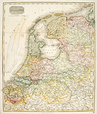
HOLLAND.
by THOMSON, John.
- Used
- Condition
- Used
- Quantity Available
- 1
- Seller
-
London, United Kingdom
- Item Price
-
SGD 300.82SGD 20.63 shipping to USA
Show Details
Description:
Edinburgh: , 1827. Handsome map of Holland, before the building of the dykes. The New General Atlas was one of the most accurate and best produced atlases of the day. Copper engraving. Original outline colour. Fine condition. Size: 49.6 x 59 cm.
Item Price
SGD 300.82
SGD 20.63
shipping to USA
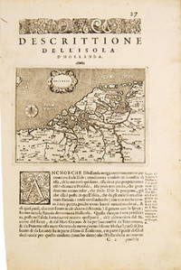
HOLLANDA.: The Netherlands.
by PORCACCHI DA CASTIGLIONE, Thomaso.
- Used
- Condition
- Used
- Quantity Available
- 1
- Seller
-
London, United Kingdom
- Item Price
-
SGD 257.85SGD 20.63 shipping to USA
Show Details
Description:
Venice: L'Isole Piu Famoso del Mondo. Simon Galignani., 1590. Map of Holland before any dykes were built and land reclaimed, showing all the original islands, Title cartouche. The maps for this atlas were engraved by Girolamo Porro from Padua, and are set within a page of text, with engraved headpiece and decorated initial. There were many editions of this popular atlas between 1576 and 1713. Copper engraving. Uncoloured. A fine, crisp impression. Fine condition. leaf size:197 x 297mm. Size: 14 x 10.5 cm. (5½ x 4 inches) Moreland and Bannister, p.68
Item Price
SGD 257.85
SGD 20.63
shipping to USA

HOLY ISLAND Staples and Barwick.
by COLLINS, Capt. Greenvile
- Used
- Condition
- Used
- Quantity Available
- 1
- Seller
-
London, United Kingdom
- Item Price
-
SGD 515.70SGD 20.63 shipping to USA
Show Details
Description:
London , 1760. Sea chart of Northumberland coast from Sunderland to just south of Berwick. Soundings and rhumb lines, north to lower edge of map. Inset map of Berwick 'Barwick') at lower left. Decorated title cartouche at top right. Captain Greenvile Collins was an outstanding naval officer who became 'Hydrographer to the King' before the Coasting Pilot was published. The Coasting Pilot was the result of the first systematic survey of British coastal waters. It took eight years to complete. The charts are notable for both their accuracy and their charm Copper engraving. Expert repairs to margins and centrefold, tiny binding holes on centrefold Size: 56 x 44 cm. Tooley, Dictionary of Maps and Map Makers p.125; Moreland & Bannister, Antique Maps p.163
Item Price
SGD 515.70
SGD 20.63
shipping to USA

HOLYHEAD.
by COLLINS, Capt. Greenvile
- Used
- Condition
- Used
- Quantity Available
- 1
- Seller
-
London, United Kingdom
- Item Price
-
SGD 515.70SGD 20.63 shipping to USA
Show Details
Description:
Great Britain Coasting Pilot., 1760. Sea Chart of Holyhead, North Wales, with rhumb lines and soundings. North to the left of map. Title in ornamental cartouche at lower left. Inset views of coastline as seen from various positions at sea ('Holyhead Nb.E 4 leagues'). Captain Greenvile Collins was an outstanding naval officer who became 'Hydrographer to the King' before the Coasting Pilot was published. The Coasting Pilot was the result of the first systematic survey of British coastal waters. It took eight years to complete. The charts are notable for both their accuracy and their charm Copper engraving. Expert repairs to margins and centrefold. Very good condition Size: 56.5 x 44 cm. (22 x 17½ inches) Tooley, Dictionary of Maps and Map Makers p.125; Moreland & Bannister, Antique Maps p.163
Item Price
SGD 515.70
SGD 20.63
shipping to USA

Didn’t find what you’re looking for?
Try adding this search to your want list. Millions of books are added to our site everyday and when we find one that matches your search, we’ll send you an email. Best of all, it’s free.
Add to Want List

Are you a frequent reader or book collector?
Join the Bibliophile's Club and save 10% on every purchase, every day — up to $20 savings per order!

Social Responsibility
Did you know that since 2004, Biblio has used its profits to build 16 public libraries in rural villages of South America?
