Maps, Mapping, Atlases from Bolerium Books Inc., ABAA/ILAB
New Arrivals
War Atlas: A Handbook of Maps and Facts
by Fry, Varian; maps by Emil Herlin
- Condition
- Used
- Published
- 1940
- Binding
- Pamphlet
- Quantity Available
- 1
- Seller
-
San Francisco, California, USA
- Item Price
-
SGD 20.51
Show Details
Description:
New York: The Foreign Policy Association, 1940. Pamphlet. 96p., stapled wraps, 5.5x7.5 inches, maps, small stain on top edge of textblock, else very good condition. Headline Books No. 23. Item Price
SGD 20.51

Farewell to Arabia
by Holden, David
- Condition
- Used
- Published
- 1966
- Binding
- Hardcover
- Quantity Available
- 1
- Seller
-
San Francisco, California, USA
- Item Price
-
SGD 20.51
Show Details
Description:
New York: Walker and Company, 1966. Hardcover. 268p., illustrated with numerous unfamiliar b&w photos and three handsome line maps, hardbound American first edition in tan cloth boards lettered dark brown, and enclosed in the dust jacket. Dj spine is mildly sunned (red has become orange) and otherwise we see no damage from handling or age. A very good copy:… Read more about this item Item Price
SGD 20.51

Fanning's Illustrated Gazetteer of the United States, Giving the Location, Physical Aspect, Mountains, Rivers, Lakes, Climate, Productive and Manufacturing Resources, Commerce, Government, Education, General History, etc. of the States, Territories, Counties, Cities, Towns and Post Offices in the American Union, with the Population and Other Statistics from the Census of 1850. Illustrated with Seals and Thirty-one State Maps in Counties, and Fourteen Maps of Cities
- Condition
- Used
- Published
- 1853
- Binding
- Hardcover
- Quantity Available
- 1
- Seller
-
San Francisco, California, USA
- Item Price
-
SGD 546.88
Show Details
Description:
New York: Phelps, Fanning & Co, 1853. Hardcover. 400p., quarter-cloth marbled boards with gilt lettering on spine, maps, tables, previous owner's bookplate on front pastedown endpaper, scattered foxing throughout, else good condition. Item Price
SGD 546.88

The Voyage of Sir Francis Drake Mapped in Silver and Gold
by Wallis, Helen
- Condition
- Used
- Published
- 1979
- Binding
- Paperback
- Quantity Available
- 1
- Seller
-
San Francisco, California, USA
- Item Price
-
SGD 16.41
Show Details
Description:
Berkeley: Friends of the Bancroft Library, 1979. Paperback. 29p., wraps, illus., spine sunned, else very good condition. Number 27 in a series of keepsakes issued by the Friends of the Bancroft Library for its members. Item Price
SGD 16.41

More Photos
Dai Nihon kokugun yochi zenzu 大日本國郡輿地全図
by Takashiba, Sanʼyu 高柴三雄
- Condition
- Used
- Published
- 1849
- Binding
- Paperback
- Quantity Available
- 1
- Seller
-
San Francisco, California, USA
- Item Price
-
SGD 1,025.40
Show Details
Description:
Edo: Tsutaya Kichizo, 1849. Paperback. Approximately 57x29 inch map of Japan's prefectural divisions, folded in dark paper cover with title label, notes written with brush on rear cover. Some splits along the folds have old repairs to the rear, while other splits remain unbacked. A good candidate for professional rebacking. Small label of the bookseller J. Stanoff, a specialist… Read more about this item Item Price
SGD 1,025.40
![San Francisco Murals [map]](https://d3525k1ryd2155.cloudfront.net/h/934/107/1593107934.0.m.jpg)
More Photos
San Francisco Murals [map]
- Condition
- Used
- Published
- 1978
- Binding
- Map
- Quantity Available
- 1
- Seller
-
San Francisco, California, USA
- Item Price
-
SGD 16.41
Show Details
Description:
San Francisco: S.F. Arts Commission, 1978. map. Eight panel brochure, 3.5x8.5 inches, very good condition. Hand-drawn map of the murals' locations. Item Price
SGD 16.41

More Photos
Kanpan Jissoku Nihon chizu. Kinai, Tokai, Tosan, Hokuriku. 官板 実測日本地図. 畿内・東海・東山・北陸
- Condition
- Used
- Published
- n.d.
- Binding
- Map
- Quantity Available
- 1
- Seller
-
San Francisco, California, USA
- Item Price
-
SGD 1,298.84
Show Details
Description:
n.p., n.d.. map. Large 61x90 inch map, folded into approximately 8.5x13 inch cloth-covered boards. One of four sheets published of this map of Japan based on the government's own highly accurate coastal surveillance (Kazutaka Unno, "Cartography in Japan," p. 453). No publisher's info on this quadrant of the map, but it appears to be the revised 1870 edition published… Read more about this item Item Price
SGD 1,298.84

Voigtlander exposure calculator for the entire world
- Condition
- Used
- Binding
- Ephemera
- Quantity Available
- 1
- Seller
-
San Francisco, California, USA
- Item Price
-
SGD 20.51
Show Details
Description:
Voigtlander. Ephemera. 4.25x6 inch folio with pocket containing exposure chart; illustration of world map with latitudes on the back, toned, else in very good condition. Item Price
SGD 20.51

More Photos
Kokugun zenzu 國郡全圖
by Aou Tokei 青生東谿
- Condition
- Used
- Binding
- Paperback
- Quantity Available
- 1
- Seller
-
San Francisco, California, USA
- Item Price
-
SGD 170.90
Show Details
Description:
Paperback. A Meiji or later reprint of the early 19th century atlas, in two volumes, 7.5x10.5 inches, bound with thread in traditional format, covers somewhat soiled, with bookseller's label. Item Price
SGD 170.90
![Israel in Your Pocket, A Ramblers' Guide. Volume One: Northern Israel, Second revised and enlarged Edition (1954) -[with]- Volume Two: Central Israel and Jerusalem's Old City, Bethlehem & Jericho (1953) -[with]- Volume Three: Southern Israel](https://d3525k1ryd2155.cloudfront.net/h/664/817/1577817664.0.m.jpg)
Israel in Your Pocket, A Ramblers' Guide. Volume One: Northern Israel, Second revised and enlarged Edition (1954) -[with]- Volume Two: Central Israel and Jerusalem's Old City, Bethlehem & Jericho (1953) -[with]- Volume Three: Southern Israel
by Meysels, Theodor F., in collaboration with Lucian O. Meysels. Lay-out and cover by L.F. Toby. Maps by Zvi Friedlaender
- Condition
- Used
- Published
- 1955
- Binding
- Paperback
- Quantity Available
- 1
- Seller
-
San Francisco, California, USA
- Item Price
-
SGD 27.34
Show Details
Description:
Jerusalem: Ben-Dor Israel Publishing Co. Ltd, 1955. Paperback. Respectively 129, xxvi, 127-280, xxiv, 281-398, xxiv. Matching small softbounds in upright paper covers (6.5x3.5 inches), diverse monochrome colors for each installment. Later issues were bound together in a singleton booklet. Our set, a second printing and two firsts, are edgeworn with faint abrasion to outer joints. These volumes are quite… Read more about this item Item Price
SGD 27.34

Guide to Delhi
- Condition
- Used
- Published
- 1958
- Binding
- Pamphlet
- Quantity Available
- 1
- Seller
-
San Francisco, California, USA
- Item Price
-
SGD 20.51
Show Details
Description:
Delhi: Publications Division, Ministry of Information and Broadcasting, Government of India, 1958. Pamphlet. 39p., stapled wraps, 5.5x8.25 inches, illus., fold-out map at rear, wraps lightly worn and soiled, else very good condition. Fourth revised edition. Item Price
SGD 20.51

Mexico: Land of Art and Wonder. Little Journeys into Mexico's Byways
- Condition
- Used
- Published
- 1935
- Binding
- Map
- Quantity Available
- 1
- Seller
-
San Francisco, California, USA
- Item Price
-
SGD 20.51
Show Details
Description:
Mexico City: Offset-Galas, 1935. Map. 26.5 inch map, folded to 4.5x9.25 inches, light handling wear else very good condition. Reverse of the map contains ads and tourist information. Item Price
SGD 20.51

Silence prevails; East Village Community Gardens During the Pandemic 2020
by Onda, Aki
- Condition
- Used
- Published
- 2020
- Binding
- Pamphlet
- Quantity Available
- 1
- Seller
-
San Francisco, California, USA
- Item Price
-
SGD 27.34
Show Details
Description:
New York: Self-published by the author, 2020. Pamphlet. 32x23 inch fold-out map+text in English and Japanese; maps of various community gardens in New York's lower-east side, in very good condition. Aki Onda is a "sound archeologist" of various community spaces, especially community gardens, of the last several decades in New York's lower east side. Item Price
SGD 27.34

Izu Shichitō zenzu 伊豆七島全圖 (Map of the Seven Islands of Izu)
by Tojo Kindai 東條琴臺, et al.
- Condition
- Used
- Published
- 1842
- Binding
- Map
- Quantity Available
- 1
- Seller
-
San Francisco, California, USA
- Item Price
-
SGD 888.68
Show Details
Description:
n.pub, 1842. Map. 41x29.75 inch folded map with exterior boards; several splits along the folds, should be professionally re-backed. Date of publication is from the preface by Nagayama Choen. Oriented with north to the left. The Seven Islands of Izu are off the coast of Tokyo; an inset also depicts the Bonin Islands. Item Price
SGD 888.68
![[Woodblock-printed map of the Kinki 近畿 area]](https://d3525k1ryd2155.cloudfront.net/h/309/790/1521790309.0.m.jpg)
[Woodblock-printed map of the Kinki 近畿 area]
by Tsutsui Shohachi 筒井庄八
- Condition
- Used
- Published
- 1879
- Binding
- Woodblock print
- Quantity Available
- 1
- Seller
-
San Francisco, California, USA
- Item Price
-
SGD 478.52
Show Details
Description:
Suimon Village, Nara Prefecture: Tsutsui Shojiro, 1879. Woodblock print. Untitled 26x23.75 inch map of Kinki (the region around Osaka, Kyoto, and Nara), formed by linking four woodblock prints together. Fold-creased, a couple of tiny holes, generally very good. Item Price
SGD 478.52

Manuscript map of Ōtsu 大津 (in modern day Shiga prefecture on Lake Biwa)
- Condition
- Used
- Published
- n.d.
- Binding
- Map
- Quantity Available
- 1
- Seller
-
San Francisco, California, USA
- Item Price
-
SGD 683.60
Show Details
Description:
n.d.. Map. 16.5x11 inch manuscript map, 19th century, ink brush on paper, identifying label pasted in upper left corner; mild handling, very good. This town was famous for its Ōtsu-e (traditional folk paintings sold to travelers). Item Price
SGD 683.60
![[Map of Osaka]](https://d3525k1ryd2155.cloudfront.net/h/937/239/1519239937.0.m.jpg)
[Map of Osaka]
- Condition
- Used
- Published
- 1835
- Binding
- Map
- Quantity Available
- 1
- Seller
-
San Francisco, California, USA
- Item Price
-
SGD 683.60
Show Details
Description:
Harimaya Kyubei 播磨屋九兵衞, 1835. map. 16x20.5 inch woodblock printed map, creased from folding, several small wormholes that have been repaired by re-backing. Date of this edition given as Tempo year 6. Some versions of this map have a title at upper right, but this one was printed without title. Item Price
SGD 683.60

More Photos
Nihon sankai zudō taizen 日本山海圖道大全
by Ishikawa Ryūsen 石川流宣
- Condition
- Used
- Published
- 1703
- Binding
- Map
- Quantity Available
- 1
- Seller
-
San Francisco, California, USA
- Item Price
-
SGD 8,203.20
Show Details
Description:
Edo: Sagamiya Tahē, 1703. Map. Approximately 67x34.25 inch folded map, fitted together from separate woodblock prints. The folded map is stored in a modern blue case. Examples of this map are often found colored by hand, but this example remains relatively unadorned, with only yellow coloration added to cartouches. Minor wormholing, and loss at the edges, has been stabilized by… Read more about this item Item Price
SGD 8,203.20
More Photos
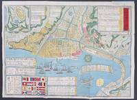
Kaisei dōban yokohama chizu 改正銅版横濵地圖
- Condition
- Used
- Published
- 1885
- Binding
- Map
- Quantity Available
- 1
- Seller
-
San Francisco, California, USA
- Item Price
-
SGD 1,230.48
Show Details
Description:
Yokohama: Ozaki Tomigorō, 1885. map. Copperplate-printed folding map with thin, flexible exterior boards, 19.5x14.25 inches when unfolded. Penciled note at upper right margin states that this was item 228 in Maggs Bros. Catalog 1311; otherwise very good to fine. Inset at lower left depicts the flags of ships that would have been spotted in the trading port of Yokohama;… Read more about this item Item Price
SGD 1,230.48
![Australia Pilot, volume I, volume II, volume III, volume IV [partial set, 4 sequential bindings, lacking supplementary installments] [Australian]](https://d3525k1ryd2155.cloudfront.net/h/844/239/1519239844.0.m.jpg)
More Photos
Australia Pilot, volume I, volume II, volume III, volume IV [partial set, 4 sequential bindings, lacking supplementary installments] [Australian]
- Condition
- Used
- Published
- 1920
- Binding
- Hardcover
- Quantity Available
- 1
- Seller
-
San Francisco, California, USA
- Item Price
-
SGD 136.72
Show Details
Description:
Washington DC: Government Printing Office, 1920. Hardcover. Ex library set in near-matching blue cloth boards, textblocks nice & clean, each with a differing folded map in colors. We see no mis-folding or foldline splits to maps; the four maps and indeed the texts themselves appear not to have been checked out or even browsed. The cloth casings on the… Read more about this item Item Price
SGD 136.72
