Maps from Harry E Bagley Books Ltd
New Arrivals

Crucial maps in the early cartography and place-nomenclature of the Atlantic coast of Canada. VI : The voyages of Jacques Cartier
by William Francis Ganong
- Condition
- Used - Fine
- Published
- 1934
- Binding
- Paperback
- Quantity Available
- 1
- Seller
-
Fredericton, New Brunswick, CAN
- Item Price
-
SGD 47.92
Show Details
Description:
Ottawa: Royal Society of Canada, 1934. Book. Fine. Soft cover. 8vo - over 7¾ - 9¾" tall. printed paper covers, 149-294 pages : maps, Cover title "From the Transactions of the Royal Society of Canada. Third series, v. 28, 1934.". Item Price
SGD 47.92

More Photos
A Complete atlas of the world: Maps of every country in the world; maps of every state in the United States featuring main automobile roads and main and branch railroads; population of principal cities in the United States and principal foreign cities; all cities and towns classified by population
by Travelguide
- Condition
- Used - Very Good
- Published
- 1928
- Binding
- Paperback
- Quantity Available
- 1
- Seller
-
Fredericton, New Brunswick, CAN
- Item Price
-
SGD 68.46
Show Details
Description:
New York: Travelguide, 1928. Book. Very Good. Soft cover. 16mo - over 5¾ - 6¾" tall. printed paper 64 pages color maps, index, with front wrap advertisement for Downyflake Doughnuts. Downyflake's is Nantucket's only classic, diner-style eatery which is still in operation. overall light soil, . Item Price
SGD 68.46

The mapmaker's eye: Nova Scotia through early maps
by Dawson, Joan
- Condition
- Used - Fine
- Edition
- 1st Edition
- Published
- 1988
- Binding
- Paperback
- ISBN
- 9780921054122
- Quantity Available
- 1
- Seller
-
Fredericton, New Brunswick, CAN
- Item Price
-
SGD 47.92
Show Details
Description:
Halifax, N.S: Co-published by Nimbus Pub. Ltd. and the Nova Scotia Museum, 1988. Book. Fine. Soft cover. 1st Edition. Oblong Folio, 26 Cm,. pictorial paper, ix, 156 pages) : illustrations, maps ; 23 x 31 cm,. Item Price
SGD 47.92

Collecting Antique Maps: An Introduction to the History of Cartography;rev. edition
by Potter, Jonathan
- Condition
- Used - Fine
- Jacket Condition
- Near Fine
- Edition
- Rev Edit
- Published
- 1999
- Binding
- Hardcover
- ISBN
- 9780951157756
- Quantity Available
- 1
- Seller
-
Fredericton, New Brunswick, CAN
- Item Price
-
SGD 47.92
Show Details
Description:
London, UK: Jonathan Potter Ltd,, 1999. Book. Fine. Hardcover. Rev Edit. 4to - over 9¾ - 12" tall. cloth, dust jacket, 207 pages : illustrations (some color), maps (some color) Includes index.. Item Price
SGD 47.92

The Crimea / the illustrations, drawn & engraved by H. Winkles ; the map, drawn & engraved by J. Rapkin.
by J. Rapkin, Henry Winkles
- Condition
- Used - Near Fine
- Quantity Available
- 1
- Seller
-
Fredericton, New Brunswick, CAN
- Item Price
-
SGD 61.61
Show Details
Description:
London : London Print. and Pub. Co Map. Near Fine. No Binding. no date,(circa 1855) map, measuring, 23 x 32 cm.,light out line colouring, Scale [ca. 1:1,220,000]. center fold, Relief shown by hachures, Includes and inset map of Sevastopol, views of Sevastopol, I?E?vpatorii?a?, banks of the Alma and Balaklava Harbor, Electric telegraph; landing place of the Allied Army, Sepr. 16,… Read more about this item Item Price
SGD 61.61
A journey back in time through maps
by Kevin J. Brown
- Condition
- Used - Fine
- Jacket Condition
- Fine
- Edition
- 1st Edition
- Published
- 2017
- Binding
- Hardcover
- ISBN
- 9788854036253
- Quantity Available
- 1
- Seller
-
Fredericton, New Brunswick, CAN
- Item Price
-
SGD 89.00
Show Details
Description:
Milan, Italy, : White Star Publishers, 2017. Book. Fine. Hardcover. 1st Edition. Folio - over 12 - 15" tall. pictorial covers,207 pages : illustrations (principalement en couleur), cartes; n our modern day and age, when satellite imagery and GPS services like Google Maps, offer strikingly accurate images of the world, we can easily forget that for most of human… Read more about this item Item Price
SGD 89.00

Official road map, Massachusetts, Connecticut, Rhode Island;1939
by H.M. Gousha Company, Shell Oil Company
- Condition
- Used - Very Good
- Published
- 1939
- Binding
- Paperback
- Quantity Available
- 1
- Seller
-
Fredericton, New Brunswick, CAN
- Item Price
-
SGD 27.38
Show Details
Description:
Chicago, Ill.: H.M. Gousha Co., , 1939. Map/Print. Very Good. Soft cover. 6 fold,1 map : color ; 44 x 59 cm., Scale [ca. 1:650,000], (W 74°--W 70°/N 43°--N 40°). Includes index of cities and towns Mileage chart, radio station guide, and ancillary maps of "Greater New York and vicinity" and "Greater Boston and vicinity" on verso a fine,… Read more about this item Item Price
SGD 27.38

British North America 1865 (Map)
by Denoyer-Geppert Company, D. G. G. Kerr (Editor)
- Condition
- Used - Very Good
- Published
- 1968
- Binding
- Paperback
- Quantity Available
- 1
- Seller
-
Fredericton, New Brunswick, CAN
- Item Price
-
SGD 130.07
Show Details
Description:
Chicago: Denoyer-Geppert Company, 1968. Map. Very Good. Soft cover. large full color linen-backed wall map, measuring 401/2 x 431/2 inches,(509.27 x 547.37 cm) from the Canadian History Series by Denoyer-Geppert Company, Chicago, its main topics being; Exploration, 1800-1865;Economic Developments; (a) Extent of Settlement, 1865,(b) Railways and Canals; (c) Trade Routes: Political Developments: Boundaries (a) With the United States. (b)… Read more about this item Item Price
SGD 130.07
Lines of Transportation. (map)
by Denoyer-Geppert social science maps, A19
- Condition
- Used - Very Good
- Published
- 1963
- Quantity Available
- 1
- Seller
-
Fredericton, New Brunswick, CAN
- Item Price
-
SGD 273.84
Show Details
Description:
Chicago: Denoyer-Geppert Social Science Maps, 1963. Book. Very Good. No Binding. 1 map : color ; 69 x 105 cm, folded to 42 x 28 cm., showing transport routes America wide.(main lines and secondary routes, divided in sections and laid on canvas, eyelets for hanging, very good condition,Scale [ca. 1:4,500,000] Denoyer-Geppert social science maps, A19. Item Price
SGD 273.84
Mr Selden's Map of China: Decoding the Secrets of a Vanished Cartographer
by Brook, Timothy
- Condition
- As New
- Jacket Condition
- As New
- Edition
- 1st Edition
- Published
- 2013
- Binding
- Hardcover
- ISBN
- 9781770893535
- Quantity Available
- 1
- Seller
-
Fredericton, New Brunswick, CAN
- Item Price
-
SGD 47.92
Show Details
Description:
Toronto: Anansi, 2013. Book. As New. Hardcover. 1st Edition. 8vo - over 7¾ - 9¾" tall. blue cloth, dust jacket, first edition, xxiv, 211 pages, 16 unnumbered pages of plates : illustrations (some colour), maps (some colour), portraits (chiefly colour)pictorial end papers, ; 24 cm.A fascinating work of history, biography, cartography, and literary mystery, Mr Selden's Map of China unlocks… Read more about this item Item Price
SGD 47.92
Map Thief, The: The Gripping Story of an Esteemed Rare-Map Dealer Who Made Millions Stealing Priceless Maps
by Blanding, Michael
- Condition
- Used - Fine
- Jacket Condition
- Fine
- Edition
- 1st Edition
- Published
- 2014
- Binding
- Hardcover
- ISBN
- 9781592408177
- Quantity Available
- 1
- Seller
-
Fredericton, New Brunswick, CAN
- Item Price
-
SGD 47.92
Show Details
Description:
New York: GOTHAM BOOKS, 2014. Book. Fine. Hardcover. 1st Edition. 8vo - over 7¾ - 9¾" tall. gilt spine, dust jacket, xvi, 300 pages : illustrations, maps, 1st edit.CONTENTS: Selected mapmakers, 1470-1860,The explorer and the thief,Small hope,A new world,Who knows the most wins,Catalog number one,Playing hardball,Upward departure,The battle of Sebec Missing maps, missing cards,Caught!,The plea,Map quest,Terra incognita,Maps Smiley admitted stealing,Additional… Read more about this item Item Price
SGD 47.92

Rise and progress of the British power in India; 2 vols
by Auber Peter
- Condition
- Used - Very Good
- Edition
- 1st Edition
- Published
- 1837
- Binding
- Hardcover
- Quantity Available
- 1
- Seller
-
Fredericton, New Brunswick, CAN
- Item Price
-
SGD 205.38
Show Details
Description:
London: W. H. Allen, 1837. Book. Very Good. Hardcover. 1st Edition. 8vo - over 7¾ - 9¾" tall. bound in full, blue polished calf, gilt spines, red leather spine labels in gilt, 2 volumes. (xliii, 699 ; 3 col. maps (folded) ; xix, 713 p.),ex library with bookplate inside front covers, ink stamps, initials at foot of spine and name… Read more about this item Item Price
SGD 205.38
Illustrated historical atlas of Prince Edward Island;
by J.H. Meacham & Company
- Condition
- Used - Very Good
- Edition
- 1st Edition
- Published
- 1973
- Binding
- Hardcover
- Quantity Available
- 1
- Seller
-
Fredericton, New Brunswick, CAN
- Item Price
-
SGD 342.30
Show Details
Description:
Belleville,Ontario: Mika Silk-Screening, 1973. Book. Very Good. Hardcover. 1st Edition. Folio - over 12 - 15" tall. atlas measuring,18"x15" inches,(46 x38 cm) green cloth, gilt title on covers, offset edition.(no color) a limited edition, no.319 of 1000, xvii, 162, (26 pp. patrons directory) pages illustrations, maps, portraits.Reprint of the 1880 ed. published by J.H. Meacham, Toronto, under title:… Read more about this item Item Price
SGD 342.30

Maps from an Italian atlas of the 16th century : Catalogue 132 : 133 maps from the Lloyd Triestino Atlas : offered for sale singly
by Kraus Hans Peter
- Condition
- Used - Near Fine
- Published
- 1970
- Binding
- Paperback
- Quantity Available
- 1
- Seller
-
Fredericton, New Brunswick, CAN
- Item Price
-
SGD 41.08
Show Details
Description:
New York : H.P. Kraus, 1970. Book. Near Fine. Soft cover. 4to - over 9¾ - 12" tall. pict.paper covers, 47 pages, illustrated, ex library with one ink stamp,. Item Price
SGD 41.08
Maps of the Ancient Sea Kings: Evidence of Advanced Civilization in the Ice Age
by Hapgood Charles H.
- Condition
- Used - Near Fine
- Published
- 1997
- Binding
- Paperback
- ISBN
- 9780932813428
- Quantity Available
- 1
- Seller
-
Fredericton, New Brunswick, CAN
- Item Price
-
SGD 43.81
Show Details
Description:
Kempton.IL: Adventures Unlimited Press, 1997. Book. Near Fine. Soft cover. 4to - over 9¾ - 12" tall. pictorial paper, 315 pages : illustrations, maps,a clean, bright copy.Hapgood utilizes ancient maps as concrete evidence of an advanced worldwide civilization existing many thousands of years before ancient Egypt. Hapgood concluded that these ancient mapmakers were in some ways much more advanced in… Read more about this item Item Price
SGD 43.81
The History of Cartography: Cartography in Prehistoric, Ancient and Medieval Europe and the Mediterranean, Vol. 1
by Harley, J. B.; Woodward, David
- Condition
- Used - Very Good
- Jacket Condition
- Very Good
- Edition
- 1st Edition
- Published
- 1987
- Binding
- Hardcover
- ISBN
- 9780226316338
- Quantity Available
- 1
- Seller
-
Fredericton, New Brunswick, CAN
- Item Price
-
SGD 205.38
Show Details
Description:
Chicago: University of Chicago Press, 1987. Book. Very Good. Hardcover. 1st Edition. Folio - over 12 - 15" tall. xxi, 599 pages, 32 leaves : illustrations, maps (some color). Item Price
SGD 205.38
Mapping of the World: Early Printed World Maps, 1472-1700
by Shirley, Rodney W.
- Condition
- Used - Fine
- Jacket Condition
- Very Good
- Edition
- 1st Edition
- Published
- 1984
- Binding
- Hardcover
- ISBN
- 9780946323036
- Quantity Available
- 1
- Seller
-
Fredericton, New Brunswick, CAN
- Item Price
-
SGD 410.76
Show Details
Description:
London: Holland Press Cartographica, 1984. Book. Fine. Hardcover. 1st Edition. Folio - over 12 - 15" tall. red cloth, gilt spine, xlvi, 669 pages : illustrations (some color), illustrated end papers,Includes index bibliography: p. xliii-xlv .this is v. 9 in the series Holland Press cartographica. . Item Price
SGD 410.76
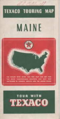
Texaco touring map : Maine with sectional map of adjacent states; 1938
by Rand McNally and Company, Texaco
- Condition
- Used - Very Good
- Published
- 1938
- Quantity Available
- 1
- Seller
-
Fredericton, New Brunswick, CAN
- Item Price
-
SGD 68.46
Show Details
Description:
chicago: Rand McNally & Company, Chicago, , 1938. Book. Very Good. No Binding. map : color ; 71 x 53 cm.,Road surface conditions edited to; Sept 1, 1938; State and Federal gasoline taxes as of Sept. 2,1938.Insets (each 9 x 8 cm.): Augusta -- Bangor -- Portland -- Quebec;Map on verso (50 x 50 cm.): Texaco sectional trip map [of… Read more about this item Item Price
SGD 68.46
Homelands and Empires: Indigenous Spaces, Imperial Fictions, and Competition for Territory in Northeastern North America, 1690-1763 (Studies in Atlantic Canada History)
by Lennox, Jeffers
- Condition
- Used - Fine
- Edition
- 1st Edition
- Published
- 2017
- Binding
- Paperback
- ISBN
- 9781442614055
- Quantity Available
- 1
- Seller
-
Fredericton, New Brunswick, CAN
- Item Price
-
SGD 51.34
Show Details
Description:
Toronto: University of Toronto Press, 2017. Book. Fine. Soft cover. 1st Edition. 8vo - over 7¾ - 9¾" tall. pictorial paper binding,pp., xii, 334 :illustrated,maps, a fine copy, CONTENTS: Introduction Chapter One: Neighbours in the Homeland Chapter Two: Mapping the Spoils of Peace Chapter Three: A Time and a Place Chapter Four: A Pale on the Coast Chapter Five: Acadia… Read more about this item Item Price
SGD 51.34
Americana; ;10 Catalogs; Nos. 3,4,5,7,8,9,10,11,12,13.
by Radford P.J.
- Condition
- Used - Very Good
- Published
- 1970
- Binding
- Paperback
- Quantity Available
- 1
- Seller
-
Fredericton, New Brunswick, CAN
- Item Price
-
SGD 102.69
Show Details
Description:
Portsmouth, England: P.J.Radford, 1970. Book. Very Good. Soft cover. Oblong 8 Vo.,. printed paper wraps, various pagination, illustrated, 10 catalogs printed 1970-75 , a long run of catalogs by long time British dealer/collector dedicated to maps of the Americas.all in very good condition. Item Price
SGD 102.69
